Tag Archives: Minnesota
An Awkward Angle
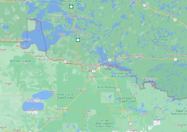
It’s a question that has bothered me since grade school geography. Why does Minnesota have that little protrusion popping out of its northern border? It’s like the state is wearing one of those little red clown hats held on by an elastic strap. I’m several decades past grade schools, but the other afternoon I was...
Big Data, Public Data
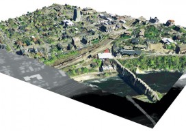
Above: A lidar-derived elevation raster DSM (of Dinkytown, MN) draped by an aerial photo. Free Aerial Lidar, Renewable Energy, an Infectious Mentality At the intersection of renewable energy, big data analysis, geospatial technology, and public data availability stands the Minnesota Solar Suitability Analysis project. Primarily manned by students in the University of Minnesota Master’s of Geographic...