It’s a question that has bothered me since grade school geography. Why does Minnesota have that little protrusion popping out of its northern border? It’s like the state is wearing one of those little red clown hats held on by an elastic strap.
I’m several decades past grade schools, but the other afternoon I was researching boundaries and from my unusual concoction of search words Google returned an item about the Northwest Angle. Unfamiliar with the Northwest Angle I swallowed the click bait and was reeled into a page about the Minnesota-Canada border.
The story—at least as this page told it—is that the creation of the Northwest Angle was the result of a surveying error. Now fully on the hook, I dug deeper and found that it wasn’t really a surveying error at all because when the original map of that area was drawn centuries ago, no actual survey was done.
A map was necessary because the British were concerned about the dangers posed to their colonies (this was pre-Revolutionary War) by the French, who owned the great and vast Louisiana Territory and also occupied areas of what would become Canada. So, George Montagu-Dunk, second Earl of Halifax and president of the English Board of Trade and Plantations, ordered colonial governors to send maps of their territory and hired John Mitchell to compile them and fill in the areas west of the colonies.
To be fair, this was the 1750s and travel to such a remote part of the world with a transit was far more complicated than a $59 Wanna Get Away flight and a rental car. And besides, at the time Britain was a naval power, seeking to expand its empire via the high seas. Little regard was given to uncharted land more than 1,000 miles from any ocean in an area that wouldn’t become Minnesota for another 100 years.
So Mitchell relied not on direct observation and measurement but reports from various people in various wilderness outposts to create a map that was to be the most comprehensive and detailed map of what was so far known of the New World from the Atlantic Ocean to the French-controlled Louisiana Territory.
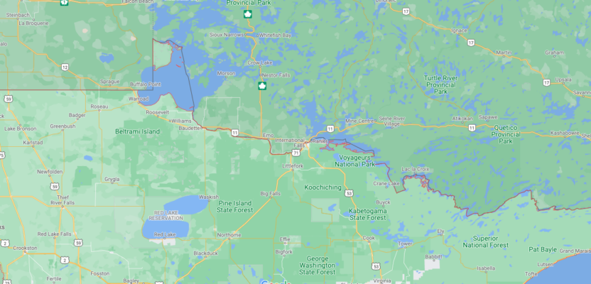
Mitchell’s survey-less map of western territory only approximated what was in that cold, remote part of the British empire. What was there—and still is there—is Lake of the Woods, the sixth largest freshwater lake that is at least partially in the United States. Mitchell assigned it an egg shape, misplaced it on the map, and created all sorts of future problems.
Historically, here’s what happened. Colonists grew weary of England’s dominance and tax policies, sought independence, fought for independence, and won independence by beating back a British invasion. But you know all that. At the negotiations for the Treaty of Paris in 1783, the official end to the Revolutionary War, the boundaries of the United States were negotiated, you guessed it, based on Mitchell’s map. Negotiators agreed that the American boundary would run from the Atlantic Ocean to the northwestern-most point of Lake of the Woods, then westward to the headwaters of the Mississippi River and then due west along the 49th parallel.
Now I’ve been to the headwaters of the Mississippi River as a stop on a family vacation when I was 9 years old. Goofing around, as 9-year-olds tend to do, I actually fell into the mighty Mississippi, thankfully just a trickle and only ankle deep at that point. That incident occurred about 150 miles due south of Lake of the Woods, so you can imagine how drawing a line westward from that lake to the river would be impossible.
Not wanting to deviate from the negotiated point on the “official” map, American negotiators insisted that the northwestern-most point of Lake of the Woods, or the Angle Inlet, remain as the border between the two countries. But that spot was 25 miles north of the 49th parallel. So, a line was drawn from there back to the 49th parallel, leaving Minnesota with a bit of a top hat made up mostly of water.
How was Mitchell’s map so wrong? Turns out he wasn’t a surveyor, geographer, or cartographer. He was born to a wealthy Virginia family and trained in the medical profession at the University of Edinburgh. When he returned to Virginia, he became interested in botany. Poor health forced Mitchell and his wife to move to London (this seems odd, but we’ll go with it) where he worked as a consultant on exotic plants to English noblemen, including the Second Earl of Halifax, who apparently deemed a botanist qualified to draw a map.
Subsequent efforts to cede that part of Minnesota to Canada were unsuccessful because U.S. negotiators have never been willing to deviate from the point on the Mitchell Map, however incorrect it may have been. In 2018 there was a movement to extend the U.S.-Canada border along the 49th parallel so the Northwest Angle would become part of Canada. A petition on the We the People section of the White House website garnered 5,544 signatures, a woeful 94,456 short of what would have been needed to bring the measure up for review among White House officials.
Turns out, Angleites, as the 120 or so residents of the Northwest Angle are called, don’t want to be part of Canada anyway. They rely on fishing and aquatic tourism, mostly from Americans, who come to catch huge walleye in Lake of the Woods. But getting there from mainland America requires two international border crossings because it turns out Lake of the Woods—long since officially and accurately surveyed and mapped—makes up 70 percent of Minnesota’s top hat and separates the small spit of land known as the Northwest Angle from the rest of the contiguous 48.