Tag Archives: mobile mapping
Caught Mobile Mapping
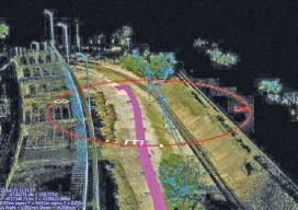
Above: Using a mobile mapping system, Construction CAD Solutions can generate high-accuracy point cloud data–in multiple views, as shown above and at left–to assist in its utility design function. Mobile mapping: A Chicago firm uses lidar innovation to survey for fiber infrastructure–for hundreds of miles. By Larry Trojak The ability to identify, accept, and then...

xyHt News Links: 10/14/16
Delair-Tech Announces Acquisition of Trimble’s US drone company Applanix Announces POSPac MMS 8 Featuring Post-Processed Trimble CenterPoint RTX Service for High-Accuracy Mobile Mapping Brand-new Optech Polaris terrestrial laser scanner launches at INTERGEO 2016 Teledyne Optech unveils the ultra-light Maverick for mobile asset mapping Orbit GT unveils Mobile Mapping Feature Extraction v17 features microdrones™ Offers Full...
xyHt News Links: 9/16/16
Septentrio Launches New GNSS Receiver for Time and Frequency transfer applications Leica Geosystems launches HDS University Teledyne Optech Press Release: Solutions for wide-area mapping and infrastructure/mine surveys at Geomatics Indaba 2016 Topcon announces enhancements to UAS packages Orbit GT and AAM Group, Australia, join forces to open new horizons in the Mobile Mapping Market Announcing...

Demystifying Mobile Mapping
Above: A mobile mapping rig of the engineering consulting firm Tetra Tech; the crew mapped the entire 288 miles of roadways in the city of Redmond, Washington in six days of driving. A surveyor examines (and asks users a lot of questions about) the Pegasus:Two system. Editor’s note: How could measurements taken from a moving vehicle...

xyHt Magazine February 2016 Issue
Click here to view the February 2016 issue of xyHt magazine

Signs of Change
Above: This image, created with Woolpert’s online QC tool eQAS, illustrates the ability to review sign data from multiple perspectives and provides lidar and image data at the location of each sign. One collect, multiple uses. A mobile mapping system (MMS) is a versatile tool capable of creating both GIS asset inventories and design-level mapping...