Tag Archives: Optech Teledyne
After the Storm
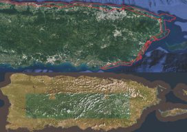
Above image: Puerto Rico was surveyed using the Coastal Zone Mapping and Imaging Lidar system to provide efficient damage assessment. Image courtesy of the Joint Airborne Technical Center of Expertise. Post-hurricane coastal mapping is a complex process made easier with airborne bathymetry. Lately, large storms such as hurricanes, cyclones, and typhoons have been wreaking havoc...

xyHt News Links: 4/8/16
Teledyne Optech Press Release: Teledyne Optech to unveil autonomous mapping system at SPAR 3D NCTech unveils new 360 degree imaging developments for iSTAR camera Teledyne Optech to announce new airborne system at ASPRS Imaging & Geospatial Technology Forum (IGTF) Trimble GNSS Options For CEESCOPE Teledyne to Acquire CARIS New Veripos GNSS Visualisation Software Fast Growing AirMap...