Tag Archives: QSI
HSI on the Fly
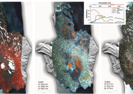
One company details mapping applications of airborne hyperspectral imagery for agriculture, forestry, and resource mapping. By Patrick Burns and Scott Nowicki, PhD Remote sensing imagery has been collected with many different camera systems for many different applications over the past 50 years of the industry. Visible remote sensing imagery provides interpretable information available to most...