Tag Archives: Schonstedt
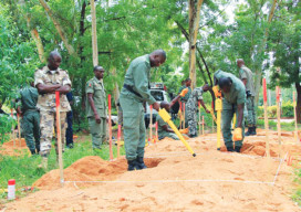
Locating More than Monuments: Demining with Schonstedt
How the Schonstedt Humanitarian Demining Initiative works—and how you can help. You know the magnetic locator well, no doubt. Whether yours is a Schonstedt or another brand, geospatial professionals are familiar with these instruments due to their common use in detecting survey markers. Border-marking studs, often sunk by surveyors gone by, are made of the...

Weekly xyHt News Links: 04/20/2018
SimActive Automates Drone Data Processing Exact Metrology Introduces Artec Ray Laser Scanner Teledyne Optech to showcase its Airborne and Terrestrial survey systems at GEOINT 2018 ENGINEERSUPPLY ANNOUNCES NEW PRODUCTS FROM SCHONSTEDT SPAR 3D Expo & Conference 2018 Keynote Speakers Announced Trimble Announces New Field Solutions for Land and Construction Surveying New Indoor Mobile Mapping System...
xyHt Weekly News Links: 10/6/17
INTERGEO 2017 successfully closes Topcon showcases ‘The Intersection of Infrastructure and Technology’ solutions at INTERGEO 2017 Rex is Here! LAStools Win Big at INTERGEO Taking Home Two Innovation Awards Hexagon Acquires Luciad, a Leading Provider of 5D Visualisation and Analysis Solutions
xyHt Weekly News Links: 8/25/17
Introducing SXblue Ultimate Survey Grade GNSS Receiver Joint NASA-Brazil CubeSat mission will unlock equatorial phenomena that affect GPS Geodetics Inc. Announces Point&Pixel Solution Allowing Photogrammetry While Reducing the Need for Ground Control Points Win a Free Schonstedt!