Tag Archives: topobathy
NOAA Advances Deep Channel Topobathy Lidar for Groundbreaking Alaska Project
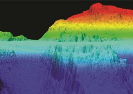
Steep and rugged cliffs, rocky shores, changing turbidity, underwater hazards, and unpredictable weather are some of the extreme challenges of mapping the coastline and waters surrounding Alaska. However, a new topobathymetric lidar project for the National Oceanic and Atmospheric Administration (NOAA) conducted by NV5 Geospatial is leveraging a state-of-the-art combination of advanced remote sensing technologies...