 Steep and rugged cliffs, rocky shores, changing turbidity, underwater hazards, and unpredictable weather are some of the extreme challenges of mapping the coastline and waters surrounding Alaska. However, a new topobathymetric lidar project for the National Oceanic and Atmospheric Administration (NOAA) conducted by NV5 Geospatial is leveraging a state-of-the-art combination of advanced remote sensing technologies to deliver new insights on the coastal waters of a dynamic landscape.
Conditions in and around the Revillagigedo Channel have made it all but impossible to acquire sonar in nearshore areas. As NOAA began mapping the waterways in this part of southern Alaska, it was vital to remotely collect data at this dangerous interface between a rocky shoreline and open waters, ensuring the safety of the boat crews doing hydrographic surveys offshore.
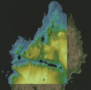
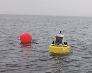
NOAA joined forces with NV5 Geospatial to leverage the company’s unique array of sensors and better understand the environment. The company planned and executed an 846-square-mile aerial acquisition, conducted as weather permitted from June through early August of 2021. In coordination with flight operations, NV5 Geospatial deployed buoys through the survey area to monitor water turbidity and performed ground surveys limited to access via remote communities or by boat.NV5 Geospatial completed the aerial survey using Leica Chiroptera 4X/Hawkeye 4X topobathymetric lidar sensors, combined with the Reigl 1560ii Near Infrared (NIR) sensor and UltraCam Eagle for four-band imagery.
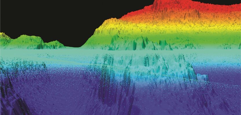
The survey resulted in bathy laser penetration of 16 meters to more than 23 meters, with an average depth of extinction of about 12 meters. The resulting submerged topography highlighted areas of rocky outcrops, shoals, and pervasive kelp beds.
This work in Alaska is part of a larger national shoreline mapping project being undertaken by NOAA to gather baseline data that will enable it to update nautical charts, manage coastal resources, and define U.S. territorial limits. The data collected also can support maritime trade and transportation and wave and wind energy site selection. In addition to potential economic benefits, this data also supports coastal resiliency efforts that include modeling sea level change, storm surge, coastal flooding, and pollution trajectories, as well as the analysis and monitoring of the environment and critical habitats; developing land and marine GIS base layers, and many other potential applications.
 Company Profile: NV5 Geospatial is North America’s pioneer for geospatial science, providing end-to-end solutions and insights to organizations that need data and analytics to mitigate risk, plan for growth, better manage resources, and advance scientific understanding. We combine the widest array of advanced remote sensing technologies with proprietary processes, analytics tools, algorithms, and analyses tailored to meet our clients’ needs.
We are an eclectic group of innovative thinkers, problem solvers, thought leaders, and subject matter experts who are constantly looking for a better way of doing things. Only a handful of firms in North America share topobathymetric capabilities at any level, much less have our mastery of the science. We lead our peers in acquisition capabilities with leading-edge sensors and world-class experts to provide informed answers that our clients’ demand.
Topobathymetric lidar has many important applications. Among these are shoreline and coastal intelligence, habitat restoration, floodplain modeling, volumetric analysis, infrastructure planning and engineering, and coastal zone management. This specialized capability allows you to significantly increase your knowledge of the nearshore environment for improved marine resource mapping, benthic habitat mapping, shoreline delineation, nautical charting, and marine debris mapping.
 With the recent acquisition of Geodynamics LLC, NV5 Geospatial has built one of the most comprehensive suites of solutions for geospatial surveys of deep water and near-shore environments. The combination brings together complementary, advanced technologies –Geodynamics’ full-ocean depth sonar-based hydrographic and geophysical surveying with NV5 Geospatial’s topographic and bathymetric capabilities.
Visit NV5geospatial.com, join us on LinkedIn, or follow us on Twitter.