Category Archives: GNSS/Location Tech
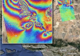
InSAR Quake “Rainbow”
This graphic, which some folks call a rippling rainbow effect, is part of the valuable post-quake analysis of the 6.4 and 7.1 magnitude earthquakes—and thousands of minor quakes—in the vicinity of Ridgecrest, California in early July 2019. This map—produced by the Advanced Rapid Imaging and Analysis (ARIA) team at NASA’s Jet Propulsion Laboratory in Pasadena,...

New GNSS Kids on the Block
Test driving a new Tersus rover: There is more to the story than a $3,000 price tag. The advent of a $3,000 high-precision GNSS rover holds a certain appeal, even more so when a test drive reveals that it holds its own with top-end rovers in many ways. But there is more to this story...
Inexpensive Does Not Mean Cheap
A revolution is happening in affordable surveying and geospatial instruments and solutions: high-precision positioning has become much more accessible and affordable for existing and emerging end-user constituencies. Many folks may have found high-precision prohibitively expensive in the past or were resigned to low-precision choices, but now there are a lot more solution developers, manufacturers, and...
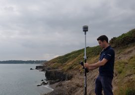
Survey-grade PPP
Above: Using a real-time PPP-capable GNSS rover on the Wicklow coast of Ireland. Credit: Niall Hand, Korec Group. Has real-time precise point positioning finally hit prime time for surveying applications? The answer is a qualified yes. The dream of being able to achieve survey-grade (2cm horizontal and 5cm vertical) GNSS-derived positions without post-processing, a base,...
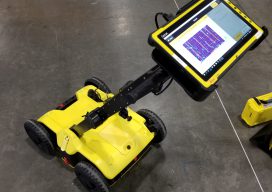
Seen at HxGN LIVE 2019
BLK2GO SLAM (simultaneous localization and mapping) lidar handhelds have become popular for BIM, as-builts, and rapid 3D modeling. The new Leica Geosystems BLK2GO shares some of the core technologies of earlier members of the BLK family (like the BLK360 scanner). What distinguishes this from many of the other SLAM handhelds is that it utilizes cameras...

Dr. Gladys West
The quiet dedication of a hidden hero who made satellite geodesy and global positioning possible. As early as high school, the focused determination of Dr. Gladys West would see her rise to make key contributions to one of the most impactful scientific endeavors of our age. In our recent interview with xyHt magazine, West gave...