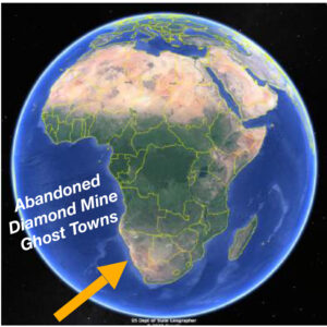
Diamond mine memories: A century or so ago, miners in the small settlement of Pomona pulled 50,000 carats of diamonds a month from the vast, arid nothingness of land called the Sperrgebiet—10,000 square miles of coastal desert in southwestern Namibia in Africa.
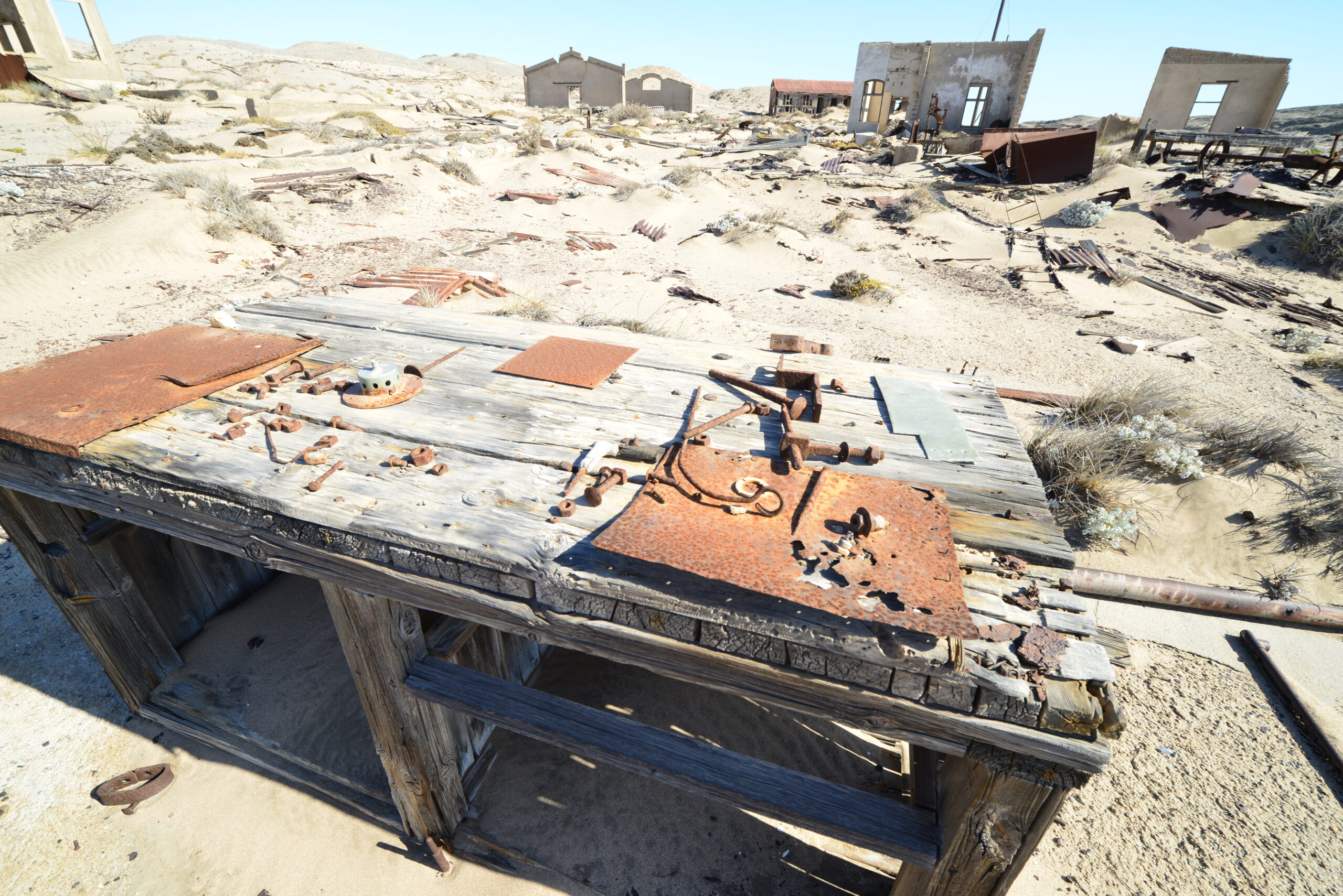
The sandy ground has long since given up the last of its precious gems, and every diamond mine has moved on to other parts of the Sperrgebiet (Prohibited Area). Life left settlements like Pomona as quickly as it did gold rush towns of the American West, and now 100 years later Pomona is a decaying ghost town.

Herman Strydom and associate Guillaume van der Walt take a break and look out over the southern Atlantic Ocean with the RIEGL VZ-2000i on the remote Namibia coast. The remains are a part of Pomona, once a thriving diamond mining town in the African Sperrgebiet.
The buildings that still stand are skeletons of the structures they once were, having been given over to the harshness of a desert climate that delivers less than two-tenths of an inch of rain annually. Roofs and windows are dilapidated and weather-beaten doors are ajar, giving desert winds unrestrained access over the years to fill former living spaces waist-deep in sand.
The Sperrgebiet has been off limits to the public for more than a century since the discovery of diamonds. But now the Republic of Namibia Ministry wants to open up tourism to these ghost towns. To do that an extensive survey of what is left of these ghost towns would be needed to develop a management plan.
Herman Strydom and associate Guillaume van der Walt take a break and look out over the southern Atlantic Ocean with the RIEGL VZ-2000i on the remote Namibia coast. The remains are a part of Pomona, once a thriving diamond mining town in the African Sperrgebiet.
The Survey and the Surveyors
Every true surveyor can recall that one special assignment so out of the ordinary that almost by default creates lifetime memories. This would be such a job for Herman Strydom and Francios Stroh. To be able to perform their craft in a remote location, away from distractions of everyday life and other human beings may be one of surveyor’s greatest pleasures. And sharing the experience with a few friends and colleagues would make it almost spiritual.
 The work at hand for Strydom and Stroh in April of this year was to create a 3D point-cloud record of several abandoned diamond mine ghost towns scattered along the coast of Namibia for the Namibian National Parks Programme of the Ministry of Environment and Tourism.
“This was definitely one of the great surveys I have been lucky to be part of,” says Strydom, who lives in Windhoek, Namibia. “We are, however, blessed with a number of amazing surveys, given the vastness, remoteness and the sparse population of Namibia.”
Their work would form a basis for the development of an integrated park management plan and the survey would provide data sets for the preparation of base plans. Based on this data, architectural decisions will be made as to which buildings will be preserved, rehabilitated, restored or reconstructed.
This incredibly beautiful, remote and practically unspoiled natural area on the southwest coast of Africa in the Namib Desert is on the cusp of a renaissance. Tourism, including ecotourism, is being planned in the area. MET architects wanted to know exactly what structures exist there today, and their condition, so that they can possibly preserve them for future generations and share them with visitors from around the world. The villages have 20 to 30 buildings each, all of which would need to be documented inside and out.
Roads and other landmarks were to be included in the data collection. Meticulous planning was essential, and one can only imagine their anticipation as Strydom, Stroh and their crews thought about everything necessary for the project, including what equipment they would need. They decided on going for a fusion of three types of collection: aerial and terrestrial lidar for the outside areas, and a smaller scanning unit for inside many of the deserted structures in once-thriving mining towns.
The two men have collaborated many times in the past on unique projects, and often they put their heads together to come up with creative ways to get the most out of the equipment.
The purpose of these scans was to document an area that has been largely untouched for the past 100 years. Despite being near the southern Atlantic Ocean, the diamond mines are in an incredibly remote area of the desert that, by design, was inaccessible by foot and dangerous to reach even by vehicle.
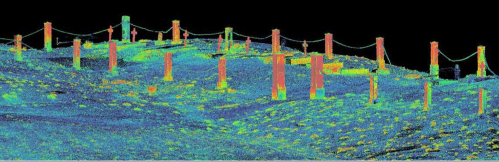
The job of creating point cloud images of several Sperrgebiet ghost towns included scanning the Pomona cemetery.
The Equipment
Strydom and Stroh put a great deal of thought into how to approach this assignment. Strydom’s company, Strydom & Associates of Windhoek, Namibia, is the most advanced survey operation in Namibia. Stroh’s company, Horts Geo-Solutions of Cape Town, South Africa, provides the latest in lidar technology equipment to industry professionals in the southern area of Africa, including and featuring the RIEGL line of instruments. Horts is a long time RIEGL distribution partner.
The RIEGL VZ-2000i terrestrial laser scanner (TLS) was provided by Stroh, who wanted to demonstrate to Strydom the differences of RIEGL’s pulse-based system versus another system that was phase based.
“It was astounding what was possible,” said Stroh. “With the RIEGL system, mounted on a shock mount we were able to drive, stop, scan for 50 seconds, and repeat every 50 meters. The sheer volume of precise data we were able to collect in such a short period of time was mind blowing. We collected the data several times faster than the other system that was used on the interiors.”
Scans with the RIEGL system took 50 seconds each, including photos. The other system took just short of two minutes to scan, and another two to three minutes to take the photos.
“The RIEGL VZ-2000i was perfect for getting the exteriors, said Strydom. “It was fast and incredibly precise. We had aerial capabilities, but the level of precision we needed on the ground made the VZ-2000i the instrument of choice. The aerial work was performed in one day, and the on-the-ground work with the RIEGL TLS was performed in a day and a half and provided much more, and much more detailed data.”
The set-up for the exterior collection with the VZ-2000i included a vehicle with a shock mount and a two-person crew to operate.
“It could have been performed with only one person, with controls inside the cab,” said Stroh. “But we wanted to move fast and also bring along a few of our colleagues who we thought would enjoy the experience.”
The Adventure
Living in Namibia and South Africa, both men knew how to plan for a week of “roughing it.” To simplify logistics, they brought along only the bare minimum of the comforts of home. The team would be moving its campsite every day as the group moved from ghost town to ghost town.
Only the necessities of tents, food and refrigeration units, changes of clothes and a toothbrush were packed. Scanners, cameras and accessories like batteries took priority within the limited cargo space. And they needed room in the vehicles for the personnel. Anything else was deemed a luxury and left at home.
“Herman and I each have freezers in our vehicles. We planned meals so the fresh food was eaten in the first couple of days,” Stroh said. “Our meat was vacuum packed and frozen so it would last well.”
They ate a lot of meat.
“The meat in South Africa is good. Namibia’s is even better,” Stroh said. “There, if you arrive at a barbeque and you ask for salad, they will offer you chicken. If you ask for vegetables, they will give you some pork.”
Most of their food was cooked over an open fire, which is called “braai,” the old Afrikaans term for “barbecue” or “roast.”
“We happened to find an old truck rim, and that became our stove throughout the trip,” said Stroh.
That was a fortunate discovery as the wind was ferocious at times. The rim, probably a century or more old, kept the coals in place and the flames from blowing out.
“The wind was something that Herman had warned us about, but we didn’t take him too seriously,” Stroh said. “Mid-day was generally calm. But during the mornings and evenings there were air rushes caused by the heat of the dessert pulling in the air from the sea, and the strong winds would reverse at other times.”
The crews arranged vehicles around the camp to provide shelter from the wind. Strydom’s local knowledge of where and how to camp in these conditions was invaluable.
“We did not want to camp up by the Bogenfels (a famous coastal rock formation in Namibia) because the wind there was quite strong,” Strydom said. “There is a cave on the seafront that would have been a lovely spot to camp, but we couldn’t get the vehicles down to it. It was too steep and we would have been too exposed.”
Wildlife was not a huge concern. “The most dangerous would have been the brown hyena or jackals,” Strydom said. “If you leave anything out they will come and eat it. They try to eat anything, including the rubber on your tires and cables. But we had no problems with them on this trip.”
Adds Stroh: “Camping. Grilling over an open fire. A dip in the ocean now and then, and lots of hard work mixed with exhaustion and laughter.”
If a man’s treasure were measured in satisfying experiences, one could say that this adventure was probably worth much more than (almost) any diamond ever mined from the Sperrgebiet.
The Results
Strydom and Stroh knew that they had collected some valuable data during the week-long expedition. But if the end product isn’t used by the designers, contractors or owners, there really is no point. So it became essential to present the data in a format that is usable to others on the project.
If others are new to the technology, the only thing to do is to walk them through the process and hope that they also see the value. The local designers on the ghost towns project were unaccustomed to working with the high-quality lidar data, let alone the fusion of data from three different types of equipment. But the architects were interested to see what could be made available.
Strydom provided the extra step of modeling the point clouds and showing the architects what was possible with the data. Normally the architects would do the modeling, but Strydom wanted to ensure that the data had the best chance of being viewed properly.
“Herman’s final deliverable overwhelmed them,” Stroh said. “The architects were so pleased that they are now using this technology on other projects. This demonstration has been a real turning point in using RIEGL lidar in Namibia.”
Sidebar: The Sperrgebiet
In 1906, railroad worker Zacharias Lewala found the sparkling gem that set off the diamond rush to the inhospitable terrain of southwest Namibia–the Sperrgebiet. Consequently, a handful of small towns sprung up in this area of the Namib Desert that stretches along the Atlantic coast for 200 miles (320 kilometers) from the South African border at Oranjemund to just north of Lüderitz.
In the early 20th century, the German Empire controlled southwest Africa and created the Sperrgebiet to give the Deutsche Diamantengesellschaft, or German Diamond Company, unrestricted access to the vast diamond deposits. The Germans lost control of the territory to South Africa during World War I and mining rights were taken over by DeBeers, which controlled the area until the Namibian government purchased a 50 percent stake in the 1990s.
The Sperrgebiet
Security is still tight in the Sperrgebiet (German for “Prohibited Area”). Anyone caught with an illegally removed stone faces up to 15 years in prison. Its few visitors and workers are meticulously searched and vehicles are X-rayed upon leaving to prevent diamonds from being slipped into gas tanks or truck frames. Equipment that enters the area never leaves. Every digging machine and truck used since the 1920s sits inside Sperrgebiet rusting away.
The old railway siding of Grasplatz is where it all began in 1906. Shifting sand dunes made it necessary for teams of workers to clear the tracks on a daily basis. It was here that Kolmanskop, six miles outside of Lüderitz, was the first town to be developed—all its building material, supplies and water brought by ship from Cape Town.
Afterwards, the rush spread southwards and the small mining settlements of Pomona and Bogenfels sprang up.