Category Archives: Press Releases

Weekly xyHt News Links: 03/1/2019
Esri Acquires indoo.rs and Announces ArcGIS Indoors Release Bentley Systems Introduces Mixed Reality App for Infrastructure Construction Projects Using Microsoft HoloLens 2 at Mobile World Congress Event Trimble Announces Next Generation Mixed-Reality Device with Microsoft HoloLens 2 Technology for Front-Line Workers in Construction, Oil and Gas, Manufacturing and Mining Hexagon Advances its 5D Visualisation Portfolio...
Weekly xyHt News Links: 02/22/2019
New Lightweight, Rugged Trimble T7 Tablet Elevates Productivity on the Construction Site Ordnance survey’s DRONE mapping project: Pilotless planes that fly at 67,000 feet, run on solar power and stay aloft for months at a time will observe anywhere in the world in a single flight FARO® Introduces FARO RevEng™ for Design Professionals Topcon’s MAGNET...
Weekly xyHt News Links: 02/15/2019
Trimble Launches Division Dedicated to Advancing Commercial Map-Centric Technology International LiDAR Mapping Forum Draws 1,682 Professionals for Education, Networking, and Geospatial Technology NavVis now uses SLAM to automatically remove point cloud artifacts UgCS introduces Telemetry Sync tool for DroneLogbook MAPPS Presents the 2018 Geospatial Products and Services Excellence Awards SimActive Expands its Partner Network for...
Weekly xyHt News Links: 02/08/2019
Sokkia introduces integrated receiver for diverse applications NGS to perform another Multi-Year CORS Solution Delair launches delair.ai, industry’s most powerful aerial intelligence platform, to unlock the value of drone data collection for enterprises Teledyne Gavia Introduces SeaRaptorTM 6000m AUV at Ocean Business INTERGEO Post Show Report 2018
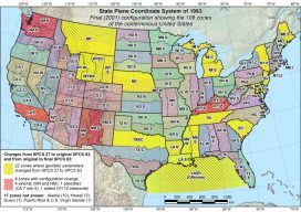
NGS Webinar on State Plane Coord. System Update
NGS’s free webinar on the State Plane Coordinate System Update has been rescheduled after the Federal government shutdown. It now will take place on March 7, 2:00 pm EST. Leading it will be Michael Dennis, PE, LS, National Geodetic Survey. NGS will establish the State Plane Coordinate System of 2022 (SPCS2022) as part of modernizing the National Spatial...
Weekly xyHt News Links: 02/01/2019
CompassDrone, Newest Division Of CompassData, Integrates UAV LiDAR Solutions RIEGL announces expansion of their global presence in Australia and Oceania: New RIEGL office in Australia opened! Sokkia introduces integrated receiver for diverse applications CompassData’s Celebrating 25 Years Dedicated To Excellence in GeoSpatial Technology FLIR Systems Acquires Aeryon Labs for $200M