Tag Archives: Aerial Surveying

AI in the Sky
Will artificial intelligence solve the beyond visual line of sight problem for uncrewed aerial vehicles? For more than a decade now we have been moving more and more processes and tasks from crewed aviation to drones in a variety of industries, but the promise of widespread massive deployment of these electrically powered wonders is still...

When a Drone Just Can’t Do It
There is a growing ebb in the tide of UAS adoption for aerial surveying, mapping, and remote sensing—finding the right balance between manned and unmanned aerial operations Unmanned aircraft systems (UAS), remotely piloted aircraft systems (RPAS), or just plain old “drones”—call them whatever you wish—have had a tremendous impact on geospatial industries. A decade ago,...

xyHt Weekly News Recap: 09/03/2021
Digital Twins Concept Boosts Food Production AgEagle CEO Brandon Torres Declet to Give Keynote Address at Commercial UAV Expo Cepton to Showcase Automotive Grade Lidars at IAA Mobility and AutoSens EAASI Elects Executive Committee to Promote Aerial Surveying in Europe Esri Releases ArcGIS Pro Book Updated for Version 2.8 Wipro and HERE Partner to Provide...
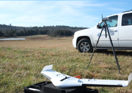
Sponsored: How Crafton Tull surveyed a 9,000 acres pipeline project in less than 45 days with a fixed-wing drone
Crafton Tull deploys Delair’s UX11 drone for oil and gas pipeline planning survey Facing a tight deadline, Crafton Tull turned to Delair’s UX11 drone to survey a 52-mile, 9,000-acre corridor for a new oil and gas pipeline—saving time, money, and producing a detailed survey that met its client’s requirements. Planning an oil and gas pipeline...
Weekly xyHt News Links: 3/24/17
GEO Business 2017 Launch Cutting Edge Workshop Program SimActive and Tianlifa Launch Integrated UAV Solution WEBINAR | How To Take Aerial Surveying To The Next Level With NEXUS SBG Systems to announce a new generation of the Ekinox Series of inertial sensors. Introducing Polaris — Next-Generation Terrestrial Laser Scanner West Virginia Implements Drone Legislation Senate...