Tag Archives: antarctica
Maps As Art
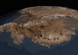
Under Antarctica’s Great Ice Sheet The topography of the bedrock under the Antarctic Ice Sheet is critical to understanding the dynamic motion of the ice sheet, its thickness, and its influence on the surrounding ocean and global climate. In 2001, the British Antarctic Survey (BAS) released a map of the bed under the Antarctic Ice...

Aerial Imaging in Antarctica
It was quite an adventure: an all-or-nothing mission to map a research station in Antarctica. Like numerous countries around the world, Ecuador’s mapping agency, Instituto Geografico Militar (National Military Geographic Institute of Ecuador or IGM), is a technical institution within the country’s military establishment. The IGM is responsible for developing the national mapping and the geographic...