Tag Archives: EagleView

xyHt Weekly News Recap: 01/26/2024
TopGIS Elevated 3D Visualization Capabilities with UltraCam Osprey 4.1 Esri Launches Maps.com, a Content Platform for Creators Demonstrating the Power of Maps ComNav Launches New P6H Handheld for GIS: A Blend of Enhanced Precision and Superior Portability Lidar Reveals 2,500-Year–Old Cities Hidden in the Amazon Techtree Innovation Launches 3D Geospatial Map Platform Commercial UAV Expo...
xyHt Weekly News Recap: 02/24/2023
2023 NSPS Day on the Hill FIG Working Week in Orlando Registration URISA Exemplary Systems in Government Awards Open NV5 to Support Statewide Imagery for Kentucky Geo Business 2023 Registration Open Three Innovative Solutions Selected in “Pitch the Press” at Geo Week 2023 Commercial UAV Expo Call for Presenters EagleView Revolutionizes Asset Management with AI-Based...
xyHt Weekly News Recap: 04/08/2022
FIG Congress 2022 in Warsaw: Registration Now Open Gold Shovel Association to Become Part of Common Ground Alliance 3,500 Attend Amsterdam Drone Week URISA Accepting Nominations for the GIS Hall of Fame Australian Firms Deliver High-Resolution Hyperspectral Earth Observation Microsatellites CoreLogic and EagleView Enhance Claims Processing Automation Quanergy 3D Lidar Flow Management Solution Deployed to...

Aerial Imagery to the Rescue
Events in 2017 demonstrated without any doubts or reservations how vitally important georeferenced aerial imagery is in assessing damage and supporting relief efforts following a natural calamity. Last September, an impromptu consortium of companies in North America mobilized their forces and collected and analyzed mountains of data at near cost to help out in what...
xyHt Weekly News Links: 9/8/17
This page includes a weekly roundup of industry news links for surveying, UAS, location technology, web mapping, hydrographics, engineering, construction, and more. NPL 322+ New Reflectorless and Prism-only Total Station SimActive Releases Correlator3D™ Version 7.0 Hurricane Harvey Early Predictive Analysis with Wind and Storm Surge Data Blue Marble Provides Free Copies of Global Mapper to...
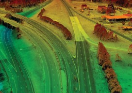
Satellite Imagery’s Impact
Above: The highest resolution of commercial satellite imagery is still more than an order of magnitude lower than the highest resolution attainable from aerial platforms. Keystone Aerial Surveys, Inc. developed this digital surface model from 1.75 cm digital imagery taken with a low-altitude flight. The resolution is sufficiently high to enable its use for mapping...