Tag Archives: eBee

Shark Week at Pangaea
With Discovery Channel’s “Shark Week” taking a big bite (sorry couldn’t help it!) out of my 4th of July weekend, my thoughts naturally turned to unmanned systems. Well, actually, thoughts on how unmanned systems are being used to study sharks with an eye to protecting both them and humans. Let’s start with that last application,...

senseFly’s Andrea Halter: From Academia to the Market
Above: This eBee Ag is outfitted with the Sequoia multispectral sensor. An interview with senseFly’s Andrea Halter Andrea Halter is a co-founder of senseFly, a Parrot company based in Switzerland that develops and produces aerial imaging drones for professional applications. Halter oversees the company’s marketing and sales teams. She’s a qualified land surveyor and holds a...
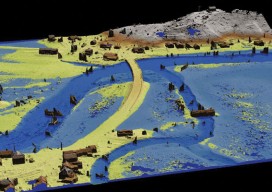
GIS-Ready sUAS
Producing GIS-ready 2D and 3D products to support decisions in transportation. Transportation planners and engineers have often made use of remotely sensed data such as overhead imagery and lidar for mapping, measuring, and monitoring transportation networks. However, despite its utility, remote sensing has failed to achieve its full potential. Remote sensing should be able to...