Tag Archives: hemisphere gnss

xyHt Weekly News Links: 9/29/17
Teledyne Optech and IGI announce new cooperative agreement and first product offering Hemisphere GNSS Debuts Next-Generation S321+ and C321+ GNSS Smart Antennas Septentrio unveils the new Altus NR3 at InterGEO GeoSLAM Launching Enhanced SLAM Software and Next Generation Mobile Scanner at InterGEO 2017 INTERGEO 2017 Berlin: Geo-IT-event officially opened Applanix Announces POSPac Cloud for Mobile Mapping...
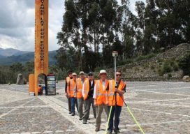
Fire, Ice, and Latitude in Ecuador
A team of U.S. surveyors visited Ecuador to use real-time PPP to pay homage to the 18th-century “Geodesic Mission to the Equator,” one of the most difficult and significant missions in the history of surveying and geodesy. Pictured above: The team of U.S. surveyors on the 2017 Ecuador visit (from back to front): Rich Leu, John...
Weekly News Recap from xyHt – 3/10/17
Orbit GT and GeoCue Group, USA, sign Reseller Agreement Topcon announces next generation concrete paving system Hemisphere GNSS Introduces IronOne Rugged Display & Computer for Machine Control Applications Hemisphere GNSS Introduces GradeMetrix™ Software for Machine Control and Guidance Applications Topcon announces agreement to bundle Bentley reality modeling software with UAS software solutions BIM: A New...

GNSS Mission: Accomplished
Above: Interviewed during our visit to Hemisphere GNSS’s headquarters, left to right: Jos Briceo, senior VP of business development; Rodrigo Leandro, senior director of engineering, and Randy Noland, VP, global sales and marketing. How a revitalized Hemisphere GNSS hit “reboot” and developed a new family of RTK and L-band positioning solutions for surveying. By Matteo...

Carlson’s BRx5 Receiver: the Birth of a New Instrument
Carlson Software & Hemisphere GNSS Bring a Lightweight Receiver to Market For land surveyors and others in careers that rely on constant use of GPS and GNSS technology, not to mention the millions of consumers with receivers in their smart phones, it is easy to forget that instant location remains technologically miraculous, relying as it...
xyHt News Links: 6/24/16
Control Point Acquires Stantec Tri-State Survey & Photogrammetry Group GENEQ Announces New RTK App for iOS named iSXBlue RTN FAA: Commercial drone use to take flight Summit Outlines Steps for a National Parcel System Hemisphere GNSS Announces New Eclipse Positioning OEM Boards Airbus Defense and Space and 3v Geomatics Partner for TerraSARX Imagery Acquisition Program...