Tag Archives: NGS

xyHt March 2016 issue
Click here to view the March 2016 issue of xyHt magazine.
NGS Finds a Real-Time Solution
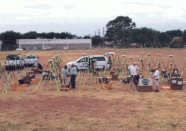
An Iowa RTN contributes to the National Geodetic Survey’s Geoid Slope Validation Survey of 2014. The gravimetric geoid model will become the zero-height surface for the new geopotential reference frame, which will replace the North American Vertical Datum (NAVD 88) in 2022. The Geoid Slope Validation Survey of 2014 (GSVS14) is the second survey conducted...

Fundamentals of Geodesy
Part 1: An Introduction Editor’s note: With this article we start an overview of GeoLearn courses offered by Dave Doyle, former chief geodetic surveyor for the National Geodetic Survey and geodesy editor of xyHt. GeoLearn (geo-learn.com) is an online education business helping professionals reach mandatory continuing education requirements and sort through everyday work issues. Dave’s...

NGA’s Involvement With Our World
Above: The deputy director says that NGA wants to have a bigger role. Editor’s Note: On July 23, xyHt editors Gavin Schrock and Dave Doyle were invited to address an audience of professionals at the headquarters of the federal government’s National Geospatial-Intelligence Agency (NGA) in Springfield, Virginia. While this was a closed-door session held to...

I Don’t Need No Stinkin’ Statistics
Surveying Statistics, Part 1 Do you perform GNSS surveys? Do you use OPUS or perform RTK surveys simply because you don’t understand your software’s output? Do you always use the compass-rule adjustment for traverse data simply because that’s the way you have always done it? Do you ever have a situation where you know something...

Survey Web Tools
How to use them for land survey planning and reconnaissance. When I first used GNSS, it was my usual practice to go to the National Geodetic Survey (NGS) website to gather the data sheets for control monuments in the vicinity of my project area. I would plot these in a program called TopoScout, a topographic...