An Iowa RTN contributes to the National Geodetic Survey’s Geoid Slope Validation Survey of 2014.
The gravimetric geoid model will become the zero-height surface for the new geopotential reference frame, which will replace the North American Vertical Datum (NAVD 88) in 2022. The Geoid Slope Validation Survey of 2014 (GSVS14) is the second survey conducted by NOAA’s National Geodetic Survey (NGS) to validate the accuracy of the gravimetric geoid model.
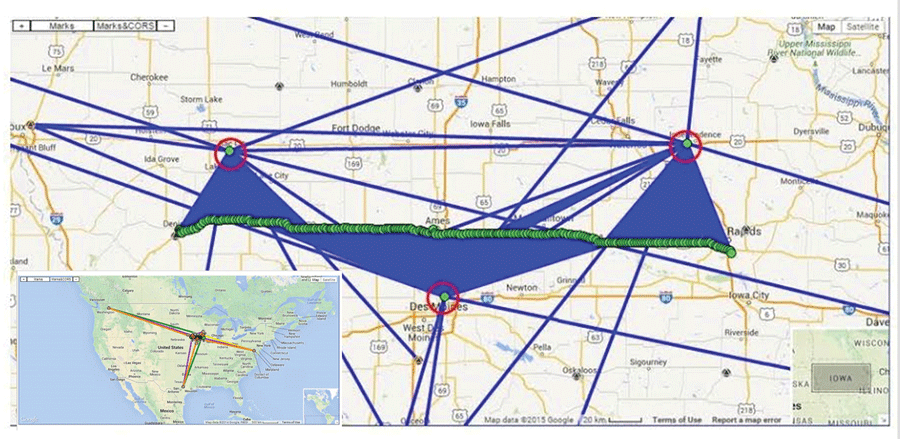
Figure 1: OPUS Projects screen capture showing the final network adjustment; the inset shows the connections to distant Continuously Operation Reference Stations (CORS).
GSVS14 was conducted in Iowa, predominantly along U.S. Highway 30 between Denison and Cedar Rapids. The survey line is approximately 200 miles long and contains 204 survey marks, hereafter referred to as official marks. The line crosses an area where the topography is relatively smooth, but with significant gravity change caused by the Midcontinent Rift. The classical NAVD 88 orthometric height along the line ranges from 740 ft to 1,440 ft.
The GSVS surveys are comprised of individual survey campaigns (geodetic leveling, absolute and relative gravity surveys, long static sessions using the Global Positioning System-GPS), and zenith camera-determined astro-geodetic deflections of the vertical-DoV). Each of the official marks participated in all of the individual campaigns.
Using the results of these independent surveys, NGS can verify with high precision and from independent methodologies the slope of the gravimetric geoid along the survey line as determined in NGS’ Gravity for the Redefinition of the American Vertical Datum (GRAV-D) initiative.
Here we describe the use of the Iowa Real-time Network (IaRTN) in support of the GSVS14 DoV survey campaign. We also compare the geodetic coordinates at 47 GSVS14 official marks that were determined using both long-session static GPS data processed with NGS’ OPUS Projects software and real-time GNSS data using the IaRTN. Note that OPUS Projects uses only GPS observation data, and the IaRTN provides a GNSS solution, incorporating GPS and GLONASS observations.
GPS Campaign and Data Processing
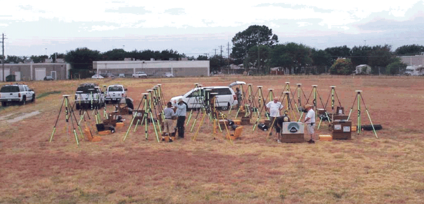
The long-session static GPS campaign consisted of two groups of ten receivers with identical antennas. Each group occupied neighboring marks simultaneously for two occupation sessions, with each session lasting between 12 and 20 hours. Two-meter, fixed-height tripods were employed and had their lengths and verticality verified at the start and end of the survey. Each static, multi-station session was processed using OPUS Projects, and later all sessions were combined in a least-squares network adjustment, also within OPUS Projects (Figure 1).
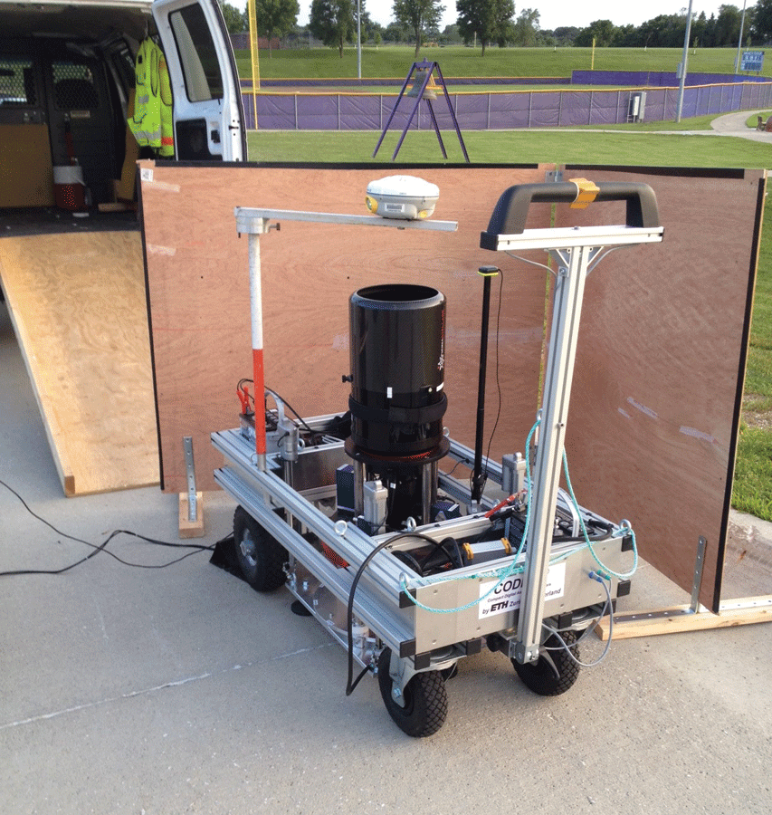
Figure 2: Typical zenith camera setup showing the RTK arm and rover deployed above the camera.
One component of the GSVS is measurement of the DoV. This is accomplished by determining astronomic latitude and longitude at each official mark location using an astrometric zenith camera, and comparing them to the geodetic coordinates that are determined using GNSS. The camera, although portable, is not well-suited for travel over rough terrain and requires a hard, flat surface to create a stable setup. This presented a challenge as many of the official marks could not be directly observed with ease due to their locations or the terrain that must be traversed to reach them. To attempt direct observation with a stable setup would require a significant additional investment in time and effort.
It was determined that all DoV observations could take place on temporary, eccentric marks as long as they were within 330 feet of the associated official marks. This would allow the DoV crew to set a nail where convenient and then take the observation over that nail.
However, this would mean that, in addition to positioning the official mark with GNSS, the eccentric mark would also have to be located. The project instructions dictated that the camera must be positioned with an accuracy of 0.3 meters (1 foot). A few options were considered, such as OPUS RS and real-time kinematic observations between each official mark and its eccentric mark. We ultimately decided to make use of the IaRTN to position the eccentric marks.
Advantages of Real-time Approach
In 2011 in Texas, NGS conducted the first GSVS project (GSVS11), with some of the DoV observations conducted on eccentric stations that were later positioned with GNSS. A problem that occurred in GSVS11 was when the eccentric station had been lost or destroyed by the time an observer returned to conduct the GNSS observations.
Note that the astronomic observations are taken at night, and under the best of conditions only ten stations could be observed each night. Taking time each night to also do the GNSS observations would have significantly slowed the crew’s progress, and there were insufficient personnel to dedicate someone to follow the crew each night to collect the GNSS observations.
Taking advantage of lessons learned from GSVS11, it was decided that a procedure for georeferencing the camera itself would be developed, and the nail would act primarily as a witness should there be a need to return later to the eccentric station.
Through the NGS Nebraska geodetic advisor (Jim Richardson), we learned of the IaRTN, operated by the Iowa Department of Transportation. We obtained an account and set Jim to work driving the line, collecting data as he went to verify the coverage of both the RTN and cellular service.
Jim also stopped occasionally to collect data on existing highly accurate marks that are published within the National Spatial Reference System (NSRS). This served to verify that the IaRTN was aligned to the NSRS. We were encouraged to find that the RTN was usable over the full length of the survey line and that the RTN-derived coordinates closely matched those of the NSRS marks.
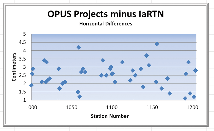
Figure 3a: Horizontal differences in the geodetic coordinates of 46 official marks
observed with OPUS Projects and IaRTN.
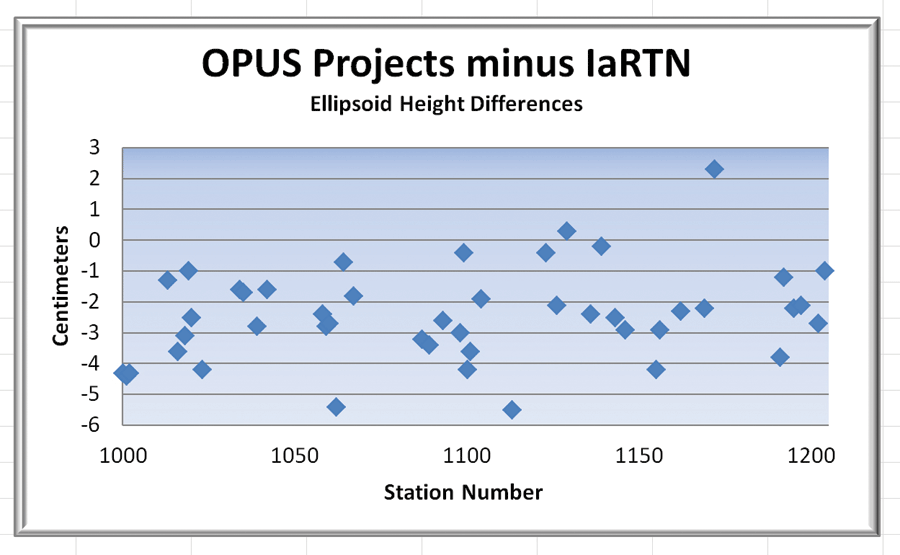
Figure 3b: Ellipsoid height differences in the geodetic coordinates of 46 official marks observed with OPUS Projects and IaRTN.
Developing RTN Methodology
A jig (RTK arm) was developed that allowed the RTN rover to be placed directly over the objective lens of the camera (Figure 2). As the camera was being leveled, the rover could be swung into place for a 60-second RTN observation, after which the rover was then swung out of the way for the astronomic observations. Hence, no time was lost as the RTN observations were taking place while other work was being executed.
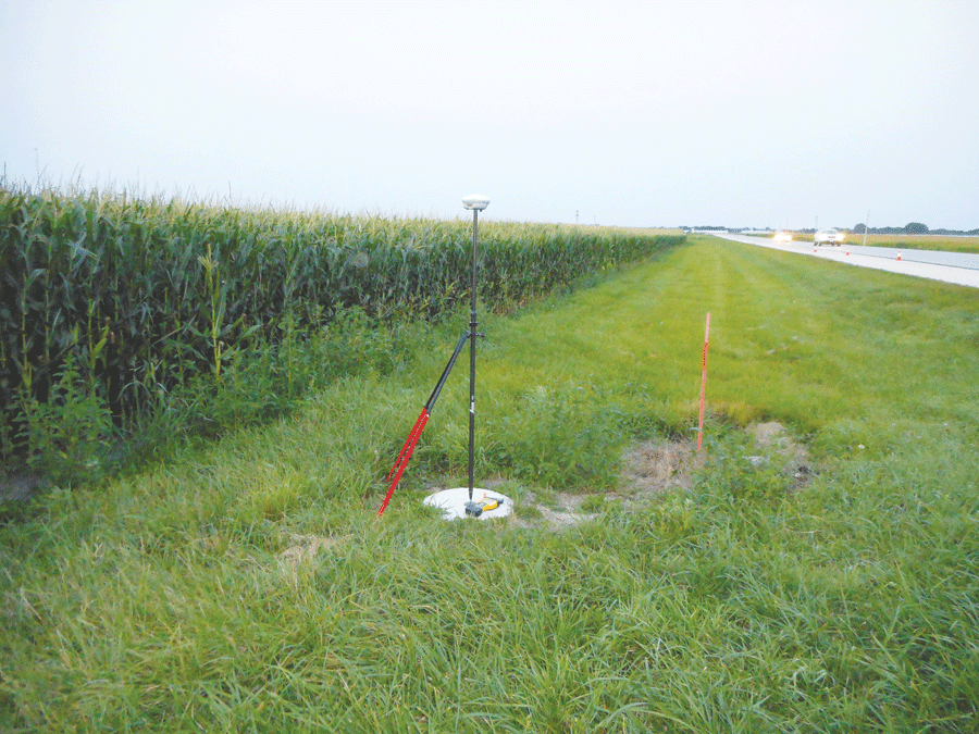
Typical GSVS official mark location.
But how were we to be sure that the RTN (and our rover) was providing accurate and precise coordinates? An observation scheme was developed that included quality control procedures to 1) ensure that the RTN was operating properly by collecting a position on the official mark that could later be compared to the position derived from OPUS Projects, and 2) ensure that the rover was operating properly and that the fixed solution was verified by collecting redundant observations at the eccentric mark/camera location using different RTN initializations.
Below is the observation procedure that was developed (note that the astronomic observations were taken using four different camera orientations):
- Locate camera center with 60-second RTN observation while camera is being leveled.
- Move rover to two-meter bipod and collect 60-second observation on official mark (first and last observation of the night only) while astronomic observations are being taken.
- About 10 minutes before the astronomic observations are complete, collect a second 60-second RTN observation on the official mark and compare to the first for agreement (≤ 5 cm) and accept the average to be the reported RTN position of the official mark (first and last observation of the night only).
- Move the rover back to the RTK arm and collect a second 60-second RTN observation while the camera is being leveled between its third and fourth orientation. Compare the two RTN observations for agreement (≤ 5 cm) and accept the average to be the reported RTN position of the eccentric mark.
This procedure was followed each night. The next day, the RTN observations were downloaded, exported to a working file, and archived. As the RTN coordinates were relative to NAD 83(2011) epoch 2010.00, they were later transformed using the NGS Horizontal Time-Dependent Positioning (HTDP) transformation software to IGS08 at the epoch of observation, which is the reference frame needed for the DoV calculations.
Comparing OPUS Projects and IaRTN Results
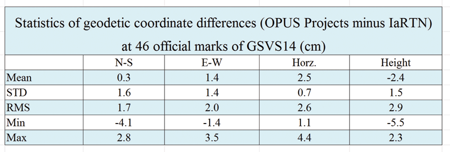
Table 1: Statistics of geodetic coordinate differences at 46 official marks.
To validate the geodetic coordinates from IaRTN that are used for the DoV computations, 47 of 204 official marks were occupied using IaRTN. The differences in geodetic coordinates of the two methods are plotted in Figures 3a and 3b. The statistics for the comparison are in Table 1. One mark (SSN 1167) that shows an ellipsoid height difference of almost 30 cm is considered to be an outlier and was removed from the coordinate comparison. Based on the field notes, it is likely that an error was made when entering the antenna height.
The results show good agreement in the geodetic coordinates between the IaRTN and long-session GPS campaign and are well within the 1-foot requirement for the DoV observation.
Of interest is an obvious bias in the ellipsoid height differences, which is evident in Figure 3b. The vertical differences are within expectations, but the OPUS Projects height is consistently less than that of the IaRTN.
There are several potential causes for this, and further investigation into the source may be made in the future.
Two long-session (12 hours or longer) GPS campaign observations were carried out on 204 survey marks along the GSVS14 line and were processed with NGS’ OPUS Projects software. Of 204 marks, 47 were also positioned with a GNSS receiver using the IaRTN. The geodetic coordinates determined using these two methods agree both horizontally and vertically within 3 cm, well within the 30 cm requirement.
Following the procedures listed above, we were able to position all 204 Eccentric Marks and 47 official marks using the IaRTN. This was accomplished simultaneously with the DoV observations and without adding significant time or expense to the project. We estimate that about two weeks of a field observer’s time was saved by using the IaRTN instead of OPUS RS to position the eccentric marks.
We thank the Iowa DOT for making their network available to us, and we appreciate Jim Richardson (retired Nebraska state geodetic advisor) for helping us to use the IaRTN.