

When Mike Lee, director of product management for the company’s spherical imaging business, sat down with xyHt at Geo Week 2026, he was not pitching a new workflow platform or a digital twin ecosystem. He was describing a company whose job is to provide a visual sensing layer that other companies’ systems depend on — and making the case that getting that layer right still matters more than anything happening further up the stack.
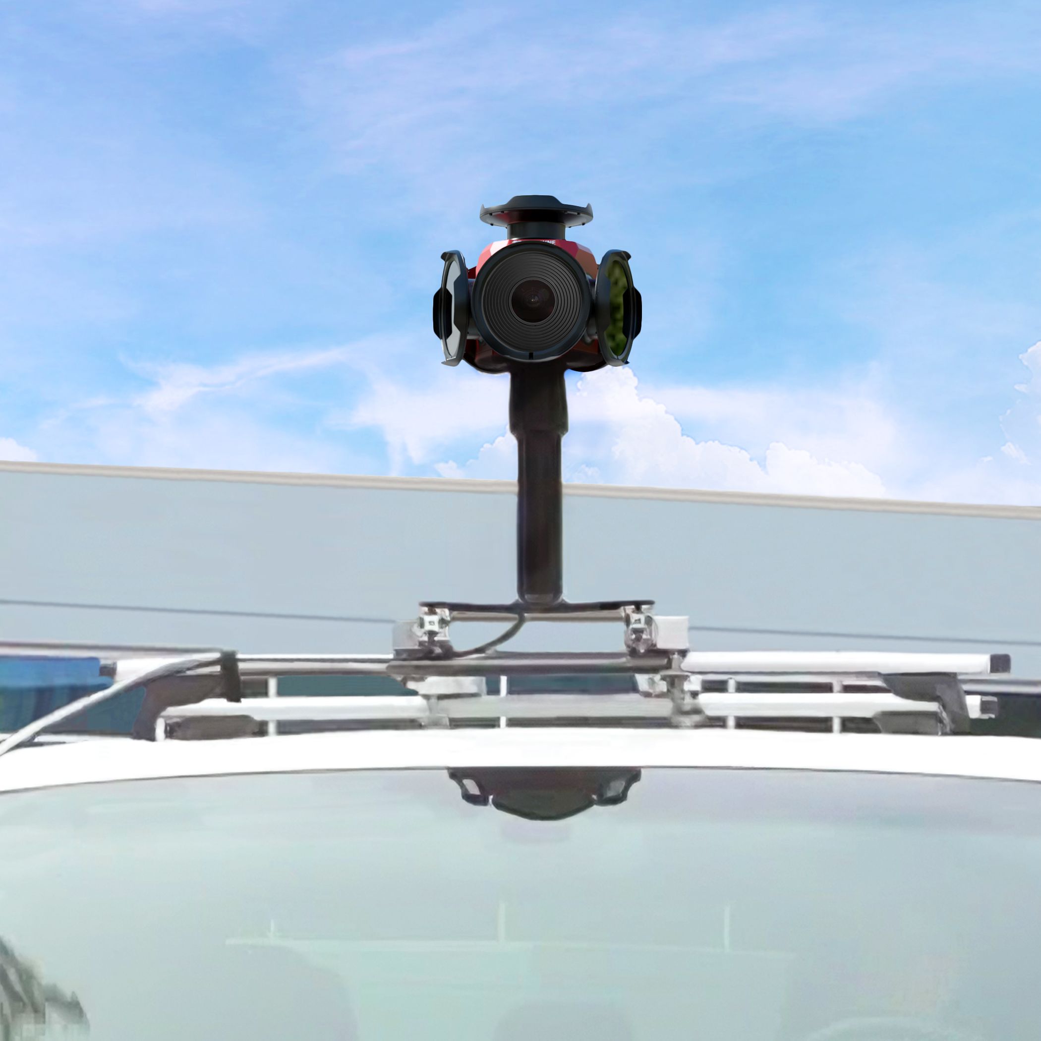
“We are embedded in a lot of products that people just don’t even realize,” Lee said. That is true in directions far beyond geospatial: diagnostic imaging systems in hospitals, quality inspection cameras in consumer-electronics factories, aerospace and defense systems. But it is especially revealing in mobile mapping, where it clarifies the company’s commercial logic. Teledyne FLIR IIS is not selling the final deliverable. It is selling the sensing component that makes other companies’ deliverables credible.

The Camera Inside the Stack
At the heart of Lee’s presentation was a deceptively simple idea: the company is often most important where it is least visible.
The digital imaging group within Teledyne’s larger organization focuses primarily on the visible light spectrum and adjacent spectral bands. In the geospatial market, however, the traction point is more specific. “When we talk about the products that have traction here within the geospatial industry,” Lee said, “it is for typically the mobile mapping applications.” Those applications span terrestrial vehicle systems, rail-mounted platforms, helicopters and ships — but the through-line is constant: an imaging subsystem that captures synchronized visual information as part of a moving, measurement-grade stack.
That positioning gives Teledyne FLIR IIS a different relationship to the market than companies that sell into the survey or GIS desktop. In Lee’s framing, the geospatial sector increasingly runs on stacks rather than single products. A mobile mapping system is already an assemblage: GNSS, inertial measurement, LiDAR, imaging, timing, capture software, post-processing, integration and then some form of asset extraction or enterprise output beyond that. In such an environment, the camera does not have to be the entire story to be mission-critical. It only has to be the component whose failure would compromise everything else.
That is the role Lee kept returning to. The Ladybug line is designed to provide visual information, color information and measurement-grade imagery as part of a system that includes other sensors. It is a core subsystem for operators who cannot afford weak links in the field.
From Industrial Imaging to Geospatial Hardware
That subsystem mentality is inseparable from the company’s background.
Teledyne is a large U.S.-based company with roots in the mid-1960s. Its stated purpose — to “enable technologies to sense, transmit and analyze information” — runs through the digital imaging group into geospatial hardware without interruption. The point is not to rehearse a corporate genealogy. It is to establish that the Ladybug line comes out of a world where image capture is expected to perform under exacting conditions and where a camera is rarely a consumer object. It is a component in a larger engineered system.
Lee’s most direct example was the Mars Perseverance mission. The cameras that captured the rover’s landing sequence — broadcast as near-real-time footage in 2020 — were designed and manufactured at the same facility that produces the Ladybug line. “It was the first time a near real-time capture of one of our instruments ever landing on a non-terrestrial body,” Lee said. “Those cameras were designed and manufactured in the same facility that I work in, which is where those machine vision cameras and the Ladybug cameras are designed and manufactured. So we come from that industrial grade engineering heritage, which we’re very proud of.”
That phrase does a lot of work. It explains why the company’s product conversation so often runs toward durability, repeatability, lifecycle and manufacturing consistency rather than pure image resolution. It explains why IP ratings, shock and vibration certification and multi-year support commitments occupy such a central place in the pitch. And it explains why the move from machine vision and aerospace imaging into mobile mapping is not actually a departure at all. These are all environments where a sensor must behave predictably under real-world operating constraints. Seen that way, the geospatial market is not a new direction for Teledyne FLIR IIS. It is a logical destination.

Why Ladybug Still Matters
The Ladybug line has been around long enough to have earned its place, not just announced it.
Lee traced the product family back nearly three decades, with the first multi-sensor camera in the line released in 2002. One of its most telling moments came a few years later, when Google was still figuring out how to engineer panoramic street-view capture. “One of the iterations, even Ladybug3, was there in the early days when Google saw what other products out there they could use for Google Maps,” Lee said. Google eventually moved to its own camera designs, but used the Ladybug platform while working through the engineering of what became Street View — a technology so familiar today, Lee noted, that people take it entirely for granted. “We were part of that journey,” he said.
That anecdote is not just a brand-name association. It marks the Ladybug line as present at the formation of large-scale, operational street-level data collection — before the current vocabulary of digital twins, AI-enabled asset extraction and smart-city analytics had arrived. What has kept the product relevant is that all of those newer layers still depend on the same root requirement: a reliable visual record of the physical environment, acquired under motion, calibrated precisely enough to align with other sensors, and rugged enough to operate at scale.
Today the line centers on two core models: the Ladybug5+ and the Ladybug6. The Ladybug5+ delivers 30 megapixels, captures up to 30 frames per second, carries an IP65 rating, weighs approximately three kilograms and operates from minus 20 to 50 degrees Celsius. The Ladybug6 more than doubles the resolution to 72 megapixels, extends the lower operating threshold to minus 30 degrees Celsius, carries an IP67 rating and captures up to 15 frames per second at full resolution. Both are built around the same core proposition: spherical, factory-calibrated imagery from a moving platform, with spatial accuracy of plus or minus two millimeters at 10 meters.
The difference between the two models is not simply better specifications in the abstract. The meaningful question, as Lee made clear, is what those specifications unlock.

When Resolution Becomes Operational
“The big thing here is the resolution,” Lee said. More precisely, “that resolution materially matters when you’re using it through running through the images through a segmentation algorithm” — through feature extraction, object classification and AI-assisted analysis downstream of human viewing. This is where the Ladybug6 story becomes most interesting, because it reveals how much of the current value in geospatial imaging lies not in what a person sees but in what software reads.
Lee’s clearest example involved fiber-to-the-home installation planning. A contractor mapping a neighborhood can use a simple workflow: measure from the centerline of each property frontage and estimate a straight path to the structure. But high-resolution imagery changes what is economically visible. By running image analytics on detailed frontage data, a contractor can determine where moving a route a few meters will avoid drilling through concrete or brick — and instead pass through grass or a garden — dramatically reducing installation time and surface restoration costs.
“That changes the economics for that service contractor,” Lee said. Multiplied across an entire neighborhood, a bidder can come in lower while preserving healthy margins. His phrase for it was precise: “It’s using geospatial information as a competitive strategy when they built it into their workflow.” And importantly, this was not a use case the company sold. The customer brought it to them as the reason they needed the higher-resolution camera.
That is an important conceptual shift. In older geospatial conversations, higher resolution was often a matter of fidelity — prettier imagery, more detail. In Lee’s telling, it is much closer to a business variable. Better imagery is not merely more accurate. It is imagery that changes unit economics because it supports classification, path selection and feature extraction at a level lower-resolution imagery cannot match.
This is also where the connection to AI becomes clear — and where Lee drew a deliberate boundary. “We are not generative AI,” he said. The company’s job is to provide “as accurate of the information that we can sense to our customers,” after which partners and customers can generate derivative information and decision support from that data. In modern mapping workflows, the visual sensor is a root condition for usable AI. If the image is poorly timed, noisy, inconsistently calibrated or operationally fragile, downstream processing can compensate only so much. Teledyne FLIR IIS is staking out the position that getting the root layer right still matters more than promising capability further up the stack.

Timing, Tolerances and the Multi-Sensor Problem
That same practical philosophy applies to timing and synchronization.
Accuracy in a mobile mapping environment is never purely optical. A camera may be excellent on its own, but in a moving system it becomes part of an error budget that includes the optical system, image processing, GNSS, motion and whatever other sensors are present. “There’s error throughout every single component,” Lee said. “But for an autonomous vehicle, they want it to be within centimeters of accuracy, which is why it’s important that we are delivering things at millimeter level, at double digit meters away. By the time you add it all together, you’re still within an engineering tolerance that is required for that particular application.”
This is where the Ladybug line’s deterministic timing becomes central. The system is designed to capture frames precisely when triggered, acknowledge that capture at the requested moment, and keep all sensors synchronized as data is logged and later fused. Lee described the workflow: “We have deterministic timing when we receive an electrical signal to trigger the camera, and then we strobe out an acknowledgement — yes, we captured the image at the time you requested it.” That precision matters when GNSS units and other sensors are logging against the same event stream. The camera is not there to decorate a point cloud with color. It is part of the metrology of the system, operating inside the same temporal discipline as every other sensor for the final fused dataset to remain trustworthy.
The system also supports PTP precision time protocol and hardware triggering and does not drift — all of which matter when customers are correlating image capture against GPS time logs across one or more sensor inputs simultaneously.
That is a subtle but consequential distinction. Plenty of geospatial conversations still treat imaging as illustrative — something that adds context after the primary measurement work is done. Lee’s discussion resists that view. In the systems Teledyne FLIR IIS targets, the image data is itself measurement-grade and directly implicated in the fidelity of the overall result. It helps determine whether an asset can be identified, whether a surface condition can be characterized, whether a route can be classified, whether a model will align.
Building for Fleets, Not Demos
If the technical argument is about accuracy and synchronization, the commercial argument is about consistency.
Lee repeatedly emphasized that the company is optimized not just for prototypes, but for scaled deployments. Customers may start with one unit for a proof of concept or a small number for a pilot, but the expectation is that they may later buy ten, twenty, fifty or more than a hundred, and that every unit must behave consistently. “They are integrated into their systems,” he said. “They’re expecting every unit to be consistent in terms of its performance.” TomTom’s mapping fleets, he noted, run Ladybug cameras at scale — a deployment that is by nature a quality control challenge as much as an engineering one.
That expectation shapes everything from manufacturing standards to documentation to support. Teledyne FLIR IIS operates as an ISO 9001-certified facility, audited annually. It provides sample code, reference libraries, API documentation, technical application notes and sample data so customers can validate the camera in their own workflows before purchasing. Multi-year warranties are standard. Product life cycles run seven to ten years — not the two-to-four-year cadence of consumer electronics — and OEM customers receive advance notice of changes, typically twelve to twenty-four months out, to protect their own product roadmaps.
“That is in our DNA,” Lee said of the commitment to long-term enterprise customers, “and we want to continue to support that.” Support teams span at least three time zones to ensure that when a customer has an issue with a camera that is part of their revenue-generating system, acknowledgment comes quickly and resolution follows.
Even Lee’s aside about hardware damage made the same point. Customers drop units. Lenses and window covers get shattered. Field hardware lives rougher lives than brochures acknowledge. “We deal with that,” Lee said — as if to say that the value of the design is not that it avoids the real world, but that it was built with the real world in mind.
What’s New in 2026
Against that backdrop, the current updates to the Ladybug line read as extensions of the existing logic rather than pivots toward something new.
Lee grouped the updates into three categories: embedded systems support, image-quality enhancement and updated mechanical finish. On the hardware side, the chassis has been updated for greater scratch resistance and resilience to everyday operational wear — a quiet acknowledgment of what years of field data looks like. On the software side, the new Ladybug SDK 1.22 improves the debayering process, which converts raw sensor data into RGB imagery, and introduces an algorithm that reduces moiré patterns, false-color artifacts and diagonal-edge aliasing — problems that emerge when imagery is processed at pixel-grouping level for segmentation and classification tasks. Crucially, that improvement came from customer feedback and sample data, not from internal roadmap speculation. “They gave us sample data,” Lee said. Within roughly a year, the company had developed, beta tested and released the update.
The embedded systems support may carry the most long-term significance. As compute costs continue to drop and capable edge hardware — specifically Jetson-class modules running on ARM processors — becomes standard in mobile mapping systems, customers want flexibility in how and where they run capture workflows. The first generation of such embedded systems, Lee noted, lacked the processing power to handle real-time capture effectively. The current generation does. In response, Teledyne FLIR IIS has released an SDK build targeting Ubuntu 22.04 LTS on ARM, allowing customers to run Ladybug capture workflows directly on that class of hardware. “If they want to run Linux on an ARM platform, they now have that option,” he said. Early customers are already operating on it.
The key point is fit rather than spectacle. The product line is not being reinvented. It is being extended in ways that track where the rest of the stack is going: smaller field computers, more flexible deployment architectures and higher expectations for imagery as machine input rather than human reference.
At the Root of the Value Chain
By the end of the conversation, Lee arrived at the clearest frame for understanding the company’s position in the market.
He sketched a value chain in which the Ladybug camera occupies the sensing layer, selling first to system builders — Trimble, RIEGL — then through service providers, and ultimately into organizations making business and operational decisions. The decision maker at the end of that chain may never look at a single image. What they see is an output: which lamp posts are approaching metal fatigue and need replacement, which pavement sections require intervention this budget cycle, where to allocate constrained infrastructure funds. The camera is buried under layers of software, analysis and workflow — but it helped determine whether those recommendations are trustworthy.
“We must provide the most geospatially accurate representation of the natural, physical world,” Lee said. “We are not using AI to do anything generative. We are making sure we provide as accurate of the information that we can sense to our customers, and then they can create the derivative information to support that business decision making.”
That is a bounded claim, deliberately so — and it holds up. The geospatial market has changed substantially since the first Ladybug systems appeared. Street-view capture has matured. Mobile mapping has scaled. AI has moved from research language to operational language. Infrastructure owners increasingly want decision support rather than raw data. Yet under all of those changes, one condition remains: the quality of the end result still depends on the quality of the sensing at the beginning.
The company’s importance is not measured by how visible it is to the end user. It is measured by how much of the modern geospatial workflow quietly depends on what it does well — ruggedized, calibrated, synchronized, measurement-grade imaging that operates inside larger systems without becoming the weak point. At Geo Week 2026, Teledyne FLIR IIS was making that case in a grounded way: not with claims to own the entire workflow, but with the narrower and more durable promise of a company that knows exactly where it sits in the chain, and why that position still matters.