Tag Archives: NV5
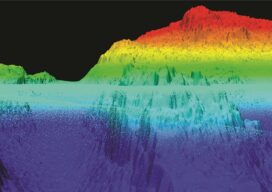
NOAA Advances Deep Channel Topobathy Lidar for Groundbreaking Alaska Project
Steep and rugged cliffs, rocky shores, changing turbidity, underwater hazards, and unpredictable weather are some of the extreme challenges of mapping the coastline and waters surrounding Alaska. However, a new topobathymetric lidar project for the National Oceanic and Atmospheric Administration (NOAA) conducted by NV5 Geospatial is leveraging a state-of-the-art combination of advanced remote sensing technologies...

Seeing the Trees and the Forest
How airborne lidar and hyperspectral imaging helps improve America’s green space and, ultimately, our quality of life

xyHt Weekly News Recap: 08/12/2021
For the 2nd year in a row, Aero-Graphics is included in Inc. Magazine’s List of the Top 5000 US companiesAEM President Dennis J. Slater to Retire after 23 Years as President Fugro Answers Remote Geo-data Needs with New Uncrewed Capability NV5 Geospatial Launches Trim Optimization Esri Offers Free Online Course on Cutting-Edge Imagery Capabilities Innoviz...
xyHt Weekly News Recap: 04/02/2021
To Russia, and Back NV5 Acquires Geodynamics; Expands Deep-Water Capabilities CHC Navigation Introduces AlphaAir Lidar System Drone Company AgEagle had Record Year in 2020 SAM Acquires R&S Digital Services Bad Elf, Point One Provide Polaris GNSS Corrections for Bad Elf Flex