Tag Archives: thermal imaging

In the Red
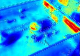
Thermal imagery helps reveal building heat loss Dr. Geoffrey Hay envisioned a solution for an invisible problem in a few milliseconds. Hay, a GIScience professor at the University of Calgary in Alberta, Canada, was perplexed by his higher-than-expected heat bills after moving into his new, modern home that was equipped with “energy-efficient everything.” It was...

xyHt Weekly News Recap: 10/15/2021
URISA Leaders Recognized at GIS-Pro 2021 Aero-Graphics Hires Daryl Southard as Director of Business Development Dewberry Acquires the Latest RIEGL VQ-1560 II-S Airborne LiDAR System Seamless, Automatic Thermal Imagery Based Inspection Available now for Remote Digital Inspections AI Surveyor is First Intelligence Platform for Large Infrastructure Projects Septentrio, ArduSimple Bringing Reliable GPS/GNSS to Emerging Applications North...
Low-cost Tech for Aerial Archeology, Part Two
To round up this short series on low-cost approaches to aerial archeology surveying, we’ll look at an even lower-cost sensor technology that can be used in certain types of archeological projects. In the first part of this series we talked about how new, affordable multispectral sensors are being used with (relatively) inexpensive UAS to find...