Tag Archives: underground utilities
3D Models Above and Below
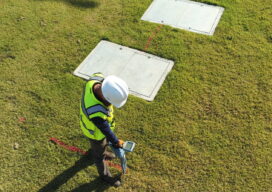
Aerial, terrestrial, and underground data tell the whole story Millions of miles of underground utilities provide U.S. communities with vital services, such as telecommunications, water, electricity, and natural gas. During construction projects, accidental damage occurs frequently due to inaccurate or non-existent documentation, a situation that can be exacerbated by inadequate research before excavation begins. Safety...
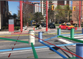
Hidden Infrastructure in 3D: Visualizing with AR
A visualization platform overlays data displays on your view of a job site by fusing data, AR software, and mobile-device sensors. From Superman’s x-ray vision, to current technologies that use radio waves to sense objects through walls. The ability, fictional or actual, to “see” through obstacles has long been a source of fascination. (Above: An...