Category Archives: Lidar/Imaging
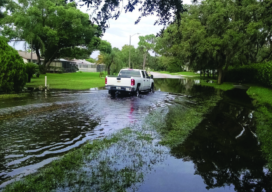
Lidar for Floodplain Models: A Project in Florida
Florida’s topology data gets a needed update with a massive project based on lidar data. Three major hurricanes (Category 4 and above) passed through the Caribbean and the Gulf of Mexico during the 2017 hurricane season—Harvey, Maria, and Irma—and they were three of the five costliest hurricanes in the United States’ history. Hurricane Irma, for...

Trends in Terrestrial Laser Scanning
Within the domain of lidar/remote sensing technologies, terrestrial laser scanning is currently the most widely adopted. Mapping drones have quickly become popular, but terrestrial laser scanning is used for more types of mapping and as-built survey applications. Other airborne (photogrammetry and lidar) and vehicle-mounted mobile scanning/mapping systems are also widely used, but there are far...
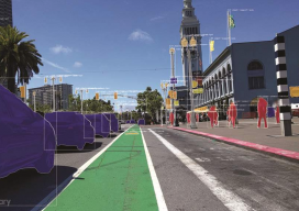
Technology to Buy Into: Riding High on AI
Artificial intelligence is making huge waves in the geospatial industry, changing how location information and BIMs are created from big data. Meet three startups at the forefront. (Image above: By applying computer vision to street imagery, Mapillary detects map data at scale.) Startups in the AEC realm have skyrocketed over the last decade. The availability...

Trimble in the Wild: Scanning the Roundest Bear
Katmai National Park broke new ground in laser scanning this October when a survey-grade scanner was used for their annual “Fat Bear Week.” Traditionally, the fatness of many a Katmai Park brown bear has been voted on by awe-struck online onlookers—the park has several webcams—and has been a matter of personal opinion gauged by eye....
Outlook 2020’s 40 Under 40
The following is xyHt’s 2020 collection of 40 under 40: profiles of motivated and accomplished young professionals under 40 years of age. Click on each name to view their profiles below. Kwabena Obeng Asiam Researcher & Lecturer – Leibniz University Published PhD candidate in land administration; FIG Young Surveyors Ghana Evaluating the evidence and making...

First Look at a New Scanner
Above: xyHt publisher Neil Sandler checks out Trimble’s X7 at INTERGEO. With the Trimble X7, there’s no going back (for calibration). About a month before INTERGEO 2019, I started to hear rumblings about a new device from Trimble. Some said it was a laser scanner, some a new total station, but no one was ready...