Category Archives: Lidar/Imaging
Seen at HxGN LIVE 2019
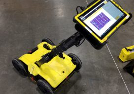
BLK2GO SLAM (simultaneous localization and mapping) lidar handhelds have become popular for BIM, as-builts, and rapid 3D modeling. The new Leica Geosystems BLK2GO shares some of the core technologies of earlier members of the BLK family (like the BLK360 scanner). What distinguishes this from many of the other SLAM handhelds is that it utilizes cameras...
Accuracy with a Phone?
Photogrammetry is now possible using consumer devices, and the applications are vast. Continuing improvement in digital cameras—including those in cell phones—and in photogrammetry algorithms have enabled dozens of consumer and professional photogrammetric applications. Among the professional ones is PhotoModeler, which produces accurate maps, drawings, CAD data, 3D models, and photos draped on 3D models. Its...
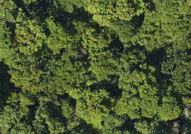
Many Sensors for a Tulip Tree Map
Above: The forests of Puerto Rico are second-growth, making for useful modeling. After hurricane deforestation in Puerto Rico, NASA scientists study forest regrowth using high-resolution, multi-sensor image data. The Biospheric Laboratory of the NASA Goddard Space Flight Center is dedicated to increasing knowledge about the Earth’s terrestrial ecosystem. One group of scientists there has been...

Touring the Leica Geosystems Facility in the UK
Getting to see Leica Geosystems’ shiny new RTC360 scanner and delve into the details were only part of a fantastic day when I toured Leica Geosystem’s facility at Milton Keyes in the UK recently. On the same site is also the UK technical support and servicing department that was only too happy to let me...
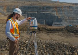
Scanning Sensitive Slopes
A team collects data with the Polaris terrestrial laser scanner at an engineered slope within the Site C construction area. Laser scanning will be a critical tool for slope monitoring during nine years of construction for a hydro electric dam in a sensitive area of British Columbia. Construction was started on the Site C hydro...
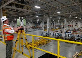
World’s Biggest Digital As-built?
Above: Darling 3D scanning division manager Charlie Warren checks his settings while scanning the Mercedes-Benz U.S. International automotive plant. A whopping 1.5-million square feet of a Mercedes-Benz facility expansion was scanned for as-built documentation and construction verification. A GROWING geospatial application of 3D digital data from laser scanners is for as-built documentation and construction verification....