Category Archives: Spatial IT/GIS
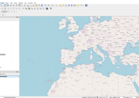
Using OpenStreetMap Basemaps with QGIS 3.0
QGIS 3 is a new wave of open source GIS. Not only is it extremely quick and efficient, allowing you to use almost every type of geospatial data you can throw at it, but it also includes a 3D renderer and ways to export your creations straight to the web. And let’s not forget the...
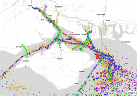
AIS: Using Shipping Data in GIS
We’ve all been dazzled by those awesome maps that animate ships or aircraft using AIS, as they move in near real time, but how do they work? What magic sits beneath the hood? As luck would have it, whilst working with the offshore wind farm industry I had to do a lot of vessel analysis,...
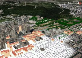
Easing the 3D Workflow
For 30 years, an Alaska-based company has been producing digital mapping and photogrammetic software to help automate the complex work of data interpretation. Photogrammetry, long the foundation of mapping, has evolved much since 1987 when DAT/EM Systems International was founded. Despite all the advances in both hardware and software, however, the latter cannot yet reliably...

Taisha Waeny
Project Manager, Esri, in Australia and New Zealand We received multiple nominations for this dynamic geospatial professional from three continents. Taisha Waeny has become one of the most-recognized voices for the international community of Esri CityEngine users and the broader geospatial community, as well. Taisha encourages young people to enter the geomatics profession by pointing...

Monica Stephens
Assistant Professor, the State University of New York at Buffalo New York, USA Big data, the geoweb, the influence of maps and mapping on society, and volunteered geographical information (VDI) are some of the subjects taught and researched by Dr. Monica Stephens. A popular educator and guest speaker, Monica is also a geo-blogger, tackling map...
Natalie Dobbs
Vice President, Spatial Innovision Ltd. Trinidad and Tobago Natalie Hobbs serves on the Vanguard Cabinet of the Urban and Regional Information Systems Association (URISA), the international nonprofit association of GIS practitioners. The Cabinet, formed in 2011, seeks to engage and support young GIS practitioners and professionals. Internationally recognized and lauded for her work in these...