All posts by Gavin Schrock
Drone Processing Services: The Importance of Keeping the Human in the Loop
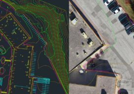
Using a drone processing service can make firms, large and small, more competitive. AI is working wonders for specific steps, but can’t do it all. Vendors and users are finding out how imprtant the human elements is. Drone-based aerial mapping and surveying has evolved, over this first decade of adoption, to include a significant amount...

What’s New EagleView?
A conversation with EagleView CEO, Piers Dormeyer about aerial imaging markets, value-added services, and what role could, and is playing in the sector.
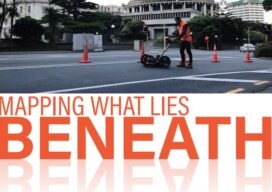
Mapping What Lies Beneath
The tools and resources for mapping underground infrastructure are rapidly evolving, but to keep up we must change our mindset of underground utility mapping.

BIM, a Basilica, and a Balloon
An award-winning digital twin project is interesting on many levels, and not just because it features one of the world’s most famous landmarks. Shown above: The AI-driven camera-based solution Italferr developed to capture the upper dome and galleries. Source: Italferr Davide Porzio, CDE manager, BIM coordinator, Italferr S.P.A. speaks enthusiastically about building a digital twin...

Preparing for the Effects of Solar Cycle 25 on GNSS Applications
As we head into the peak period for the current solar cycle, high-precision users can use space weather status and prediction resources to help plan field operations. Plus, receiver manufacturers have developed advanced mitigation solutions. Solar Cycle 25, so named as the 25th of the 11-year (approximate) cycles since 1755, when extensive recording of the...
What’s Inside Your GNSS Rover? Part 3
The third and final installment of a look at the inner workings of high-precision surveying rovers. In parts one and two, which appeared in the two previous issues, we focused on antennas, amplification, housing, channels, boards, and gates. This installment continues with signal matching, positioning engines, and additional components. Matching Signals To distill the observed...