December 2017 Archives
IoT for Construction
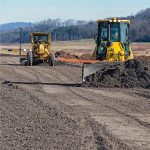
Greater interconnectivity is transforming the way we go about construction. Probably the best definition of the Internet of Things (IoT) appears in a Forbes magazine article written by the futurist Jacob Morgan; it’s the concept of “connecting any device with an on and off switch to the internet (and/or to each other).” This includes everything from […]
The Pacific Northwest
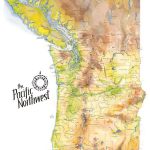
Maps as Art These earth-toned watercolors reflect the greens, browns, yellows, and blues of the verdant Pacific Northwest. I spent hours comparing source material and drawing and re-drawing this map, so I have a new depth of admiration for the mapmakers of old who pioneered this exacting business. I begin every map with a 1″ […]
Managing Canada’s Data

From mapping utility poles to mapping radio frequency signal leaks, this company collects and manages much of the country’s utilities and oil and gas data. Effigis is an interesting Canadian firm that offers a range of GIS solutions for utilities and the oil and gas industry—as well as its own GNSS positioning solution for asset inventory/mapping and utility/energy […]