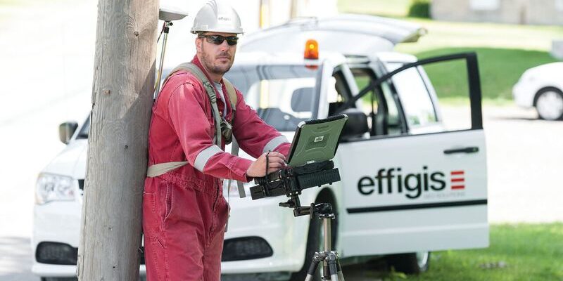
From mapping utility poles to mapping radio frequency signal leaks, this company collects and manages much of the country’s utilities and oil and gas data.
Effigis is an interesting Canadian firm that offers a range of GIS solutions for utilities and the oil and gas industry—as well as its own GNSS positioning solution for asset inventory/mapping and utility/energy field operations. A couple of years ago, Effigis might have been defined mainly by its activities in GNSS positioning, but it now has three strong business units, says Dennis Parrot, the company’s president.
Data Collection and Monitoring
Effigis’ geospatial data collection and management business unit handles large-scale data collection and management—including pole inspection, structural analysis, and inventories—for utility companies. It is currently carrying out many large pole surveys for utility companies, such as Hydro-Qubec and Bell Canada.
Pole inspections save those companies a lot of money, Parrot explains, because they enable the companies to change poles on a regular basis instead of changing them all at the end of their individual lives. This business unit also conducts fiber to the hub (FTTH) surveys.
“We are working with Bell Canada in order to help them to implement their fiber network,” says Parrot. “This is a major service that we are offering in the eastern part of Canada and plan to expand in the western part of Canada in the next few years.”
The products business unit manufactures and markets mobile monitoring solutions, including solutions for monitoring cable networks. The cable industry faces the constant challenge of keeping its networks free from radio-frequency signal leakage, Parrot explains. Effigis developed a box that cable companies can install in their maintenance trucks and use to identify those leakage points as the trucks drive along their network.
“All of this data is then transferred to our facility in Montreal where they are analyzed and then published on a website where each customer has its own area.”
Customers include Comcast, Suddenlink Communications, Charter, and CableVision.
The products business unit also makes the CPAT FLEX leakage and ingress monitoring solution and the OnPOZ suite of GNSS software. CPAT FLEX is based on an open platform and has a modular and scalable design. Cable operators can use it to monitor the quality of their networks and enhance the efficiency of maintenance operations. The OnPOZ software suite is designed to collect GIS data as well as to post-process it to improve positioning accuracy.
“Our desktop software, EZSurv, is about the only independent software on the market that is compatible with a large variety of receiver binary formats,” says Parrot. The business unit also has support teams that answer the phone and visit customers in the field to fix any problems with the equipment.
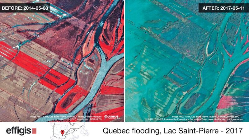
Effigis’ Earth observation business unit extracts geospatial information from digital products to support land use and management.
Earth Observation
The Earth observation business unit extracts geospatial information from digital products—including satellite imagery, aerial photography, and data from drones—to support land use and management. Its key markets are utilities, natural resources, agriculture, aeronautics, public administration and engineering, forestry, and environmental firms. It also distributes satellite imagery and provides other kinds of data-extraction services.
In some markets, it offers GNSS software mainly for GIS data collection as well as to post-process those data to improve their accuracy.
“Those are open products, compatible with many, many brands of receivers,” says Parrot.
This business unit has also put together a new service that will help farmers use the proper quantity of nitrogen in their fields by tracking such parameters as soil types and meteorological data. “We built an application where they input some basic parameters, and we output a very specific prescription for nitrogen,” says Parrot.
The Earth observation business unit distributes products from Airbus, DigitalGlobe, and Planet. “We have an order desk that looks at all the birds and determines the best to fulfill the customer’s requirements,” Parrot says. “Sometimes, we are in competition with them and other times we are a partner. It depends on the price, the territory, and the best fit for the requirement.”
Effigis’ approach is to use whatever technology will yield the best quality/price/delay ratio.
“We use satellite, aerial, or drone technology—with many different types of sensors such as multispectral cameras, radar, and lidar—with different techniques such as photogrammetry, object-oriented classification, neuronal network analysis (aka machine learning), interferometry, polarimetric analysis, hyperspectral analysis, interpolation, atmospheric correction, enhancement, and so on.”
Multidisciplinary Team
Parrot founded Effigis with his colleague Pierre Vincent. They had both worked for Lavalin, a Canadian engineering firm: Parrot as a survey project manager on international projects, mainly in Africa and Asia, and Vincent as a remote sensing specialist. Before leaving Lavalin, Parrot completed a master’s degree at the University of New Brunswick in satellite geodesy, specifically GPS positioning.
Effigis’ staff includes RF engineers, geomatics specialists, GNSS analysts, cartographers, software engineers, geologists, geographers, remote sensing specialists, and field surveyors. Its number varies seasonally, peaking at about 180 in the summer.
Effigis does not have any consumer products and does not plan to target that section of the market.
“We are really good in managing large-scale field deployment and delivering at the right time and in the right format and the right accuracy,” says Parrot.
Here’s another article by Matteo Luccio on GNSS.
To read more from this print issue, click on the cover below.