October 2018 Archives
After the Storm
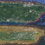
Above image: Puerto Rico was surveyed using the Coastal Zone Mapping and Imaging Lidar system to provide efficient damage assessment. Image courtesy of the Joint Airborne Technical Center of Expertise. Post-hurricane coastal mapping is a complex process made easier with airborne bathymetry. Lately, large storms such as hurricanes, cyclones, and typhoons have been wreaking havoc […]