Tag Archives: ArcGIS

Esri Partners with 3DR to Launch the ArcGIS Drone Collection
New Partnership Offers Users Best-in-Class Drone Data Capture and Analytics Solution on the Market Esri, the global leader in location intelligence, today announced that it has partnered with 3DR, a leading US drone data company, to expand Esri’s current drone imagery offering, Drone2Map for ArcGIS, with an end-to-end enterprise drone data and analytics solution for Esri’s...
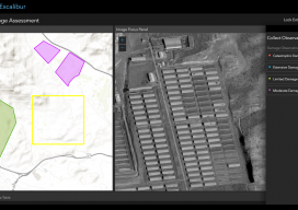
ArcGIS Excalibur
A new “un-GIS” GIS tool enables access, measurement, analysis, and markup capabilities for images – for everyone. Many years ago, during the era of cinematography and good old-fashioned film, they used to edit movies by cutting the film with a pair of 9-inch scissors; these were called “excalibur.” This sets the scene for the new...
What Is Esri?
Over the last few years we (at xyHt) have discussed Esri as an industry-leading GIS many times, but what is it? What is ArcMap, ArcGIS Pro, or any of the other things with “Arc” names? The truth is a little confusing, but at the same time a little clever. In this blog I hope to demystify...

Interview with Esri’s Jeremy Wright
At first glance, Jeremy Wright may not seem important: he’s just a product engineer for the world’s largest and most popular GIS. But when I was meeting and interviewing people in San Diego at the Esri UC for xyHt, I made a point of searching for Jeremy. He’s passionate about his work and heavily involved in...
My First Trip to the Esri UC
No matter what flavor of GIS you roll, there is no ignoring the annual Esri user conference in San Diego. The highlight is the opening plenary session which is always given by the (co) founder of Esri, none other than Jack Dangermond. To discuss this fully, we have to start at the beginning, which was...
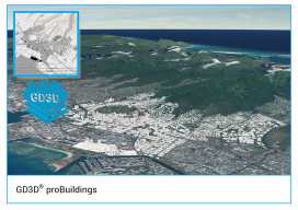
GD3D® Signs Innovative Data Agreement with CyberCity3D™ ahead of ArcGIS Marketplace Launch
(Cumbria, UK) January 23, 2018: GD3D® Signs Innovative Data Agreement with CyberCity3D™ ahead of ArcGIS Marketplace Launch PRESS RELEASE: GD3D®, the geospatial arm of Garsdale Design, is a leading 3D GIS consultancy based in Cumbria, United Kingdom. Today an agreement has been signed with CyberCity 3D Incorporated, a California 3D geospatial content company, to resell premium...