Tag Archives: Handheld LiDAR
Handheld vs terrestrial lidar for building documentation
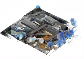
Sponsored by Paracosm Above: nmcn’s final CAD model as generated from PX-80 data. The 3D model is situated in the topographical point cloud data. Are these new tools accurate enough? Handheld mobile lidar scanners have gained market share in recent years by offering faster capture in GPS-denied indoor environments, easier documentation workflows for large, complex spaces,...

How SLAM scanning helps AkitaBox make FM a no-brainer for its customers
Sponsored How handheld 3D scanning enabled one company to capture large assets with unprecedented efficiency Like many new 3D technologies, AkitaBox’s facility management (FM) software was born when someone started asking questions about the accepted way of doing things. When co-founder Josh Lowe explains the genesis of AkitaBox, he talks about how he used to...

LiDAR for Forestry
Sponsored by Green Valley Finding DBH Values from Handheld Mobile LiDAR GreenValley International’s (GVI) LiBackpack provides mobile terrestrial and handheld LiDAR solutions that allow users to efficiently capture 3D data. As part of our LiDAR in Forestry applications series we investigated the accuracy of diameter at breast height (DBH) measurements extracted from LiBackpack data using...