Sponsored by Green Valley
Finding DBH Values from Handheld Mobile LiDAR
GreenValley International’s (GVI) LiBackpack provides mobile terrestrial and handheld LiDAR solutions that allow users to efficiently capture 3D data. As part of our LiDAR in Forestry applications series we investigated the accuracy of diameter at breast height (DBH) measurements extracted from LiBackpack data using LiDAR360’s TLS Forestry Module. We found DBH values fitted in LiDAR360 had a mean absolute error (MAE) of 3.03 cm (~ 1.19 in) and a root mean square error (RMSE) of 4.26 cm (~ 1.68 in).
About LiBackpack

LiBackpack – Handheld Mobile Mapping System
The LiBackpack is a versatile handheld mobile LiDAR system that integrates laser scanning with SLAM (simultaneous localization & mapping) technologies to rapidly generate high accuracy geospatial products with minimal data processing.
Data Collection and Processing
We selected an approximately 8100 sq. m (~2 acre) site in Berkeley, California (37.871455, -122.264097) to serve as our study area. This location contained Tasmanian blue gum (Eucalyptus globulus) and coast redwood (Sequoia sempervirens) trees planted by University of California landscape architects during the 20th Century.
The study area was surveyed with the LiBackpack system. Prior to data collection a short amount of time was spent inspecting the study site and planning the route of travel that would be taken by the LiBackpack operator. Data was collected in handheld mode to ensure that the output would contain LiDAR returns from objects in the upper most portions of the forest canopy. The operator completed two loops in roughly 10 minutes and traveled approximately 330 meters (0.2 miles). Equipment set-up and breakdown times added 5 minutes to the total workflow length.
About LiDAR360
LiDAR360 is a comprehensive software solution that provides tools for efficiently visualizing, generating & manipulating LiDAR data. A free 30-Day trial is available to all first-time users here.
The collected 3D point cloud data was then imported into LiDAR360 where it was used to rapidly generate a high-fidelity stem map and an individual tree identification system (Tree ID) which assigned a unique number to every tree. The LiBackpack data was also passed through the DBH Fitting Tool in the TLS Forest Module. Individual tree diameters were determined by first extracting a cross section of the point cloud that fell between 1.2 m and 1.4 m above ground level before manually identifying the individual tree points and then using the TLS Forest Editor to fit a circle to points that represented a tree stems hull at “breast height”. In total, 87 individual tree diameters were extracted from the LiBackpack data.
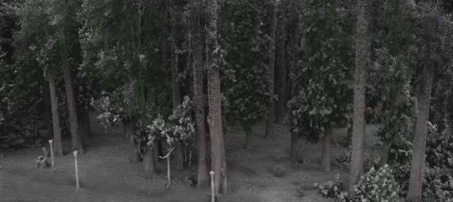
Laser return intensity used to color 3D point cloud displaying a portion of survey area

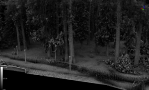
Oblique view of a bare-earth LiModel and superimposed red polyline outlining path of travel
Output from LiDAR360’s TLS Forest Module data processing workflow to extract individual tree DBH measurements. The visual outputs of the process provide a high-fidelity 2D visualization of individual tree stem locations mapped with cm-level horizontal and vertical accuracies. Each red circle represents an individual tree stem and is labeled with a unique two-digit Tree ID number. The green lines bisecting each fitted circle represent the diameter measurements attributed to each Tree ID.
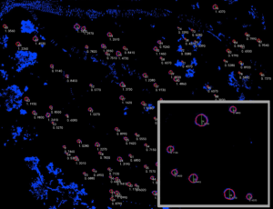
Each circle represents an individual tree stem & is labeled with a unique two-digit Tree ID
Assessment of LiDAR360 Fitted DBH Measurements
To assess the accuracy of the fitted DBH measurements generated using LiDAR360’s TLS Forest Module, a field technician took in situ stem diameter measurements of all trees located within the study area using a traditional Diameter Tape placed at a height of 1.37 m (4.5 ft) above the soil’s surface on the uphill side of the stem. Diameter measurements were taken to the nearest cm and did not included any adjustment for stem slope. The species type was also determined and recorded by the technician for all trees included in the field inventory. In total, 87 individual trees were measured for DBH.
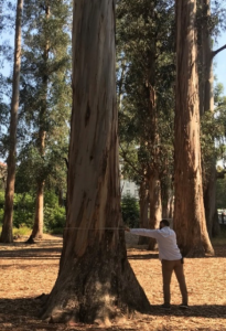
A field technician measures each tree at 1.37 m (~ 4.5 ft) above the soil’s surface on the uphill side of the stem base
DBH measurements from the field data were compared to their corresponding LiDAR360 fitted DBH measurements and the differences between the two values determined. These difference values represented the magnitude and direction of the error found in the fitted dataset at the individual tree level. When all trees for which field data was available were included in a statistical analysis of the entire study area, the mean absolute error (MAE) was determined to be 3.45 cm (~ 1.36 inches). At the site-level LiDAR360 fitted DBH values tended to be less than the field measured DBH values with 71% of the observed discrepancies between the two values being negative and the square root of the mean difference between the LiDAR360 determined DBH and field measured DBH values squared (RMSE) was 6.01 cm (~ 2.37 in).
The accuracy of TLS Module fitted DBH values was also assessed by treating the field measured DBH values as a variable that was dependent upon the LiDAR360 measurement and running a simple linear regression to determine the coefficient of variation (R²) that existed between the two related datasets.

Figure 1: LiDAR360 Fitted DBH vs Field Measured DBH scatter plots
This is an important test to run when analyzing the value of LiDAR360 extracted estimates of DBH for individual trees because it is often the case that forest inventory data is hierarchical in that individual tree level data is used to estimate plot level data which in turn is used to estimate stand and forest level data. An error in measurement of single trees carries through become error in the estimates of successively larger scale estimates of forest cover and volume. The linear regression analysis revealed that the R² value for all fitted-field measurement pairings was 0.9774 (See Figure 1).
When we removed individual trees with LiDAR360 fitted values that were more than +/- 10% of the field measured value only five trees fell out of the full dataset and the sample size decreased by just 3% to 84 trees. Doing so produced a new MAE value of 2.94 cm (1.16 inches) and RMSE value which had decreased by 30% (1.83 cm or ~ 0.72 inches) to 4.19 cm (~ 1.65 inches).
To test the influence of extreme outliers on the accuracy of the study-area level error we dropped the single most extreme outlier from the full set of error values. This sample tree had an error term that was more than 11.5 times greater than the study-area level MAE found using all fitted vs. field measured difference values. For reference, the second most extreme outlier was just under four times the MAE found using all fitted vs. field measured difference values. Removal of the most extreme outlier found in the full set of fitted DBH error values decreased the MAE to 3.03 cm (~ 1.19 inches) and the RMSE to 4.26 cm (~ 1.68 inches) while increasing the R² value of the fitted vs field collected measurement plot to 0.9886 (See Figure 2).
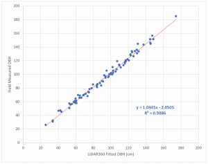
Figure 2: LiDAR360 Fitted DBH vs Field Measured DBH scatter plot, excluding the extreme outlier
Key Take-Aways
This analysis of DBH measurements derived from LiBackpack data using LiDAR360’s Forest Module demonstrated that a high level of accuracy (RMSE to 4.26 cm or ~ 1.68 inches) can be achieved. Accurate individual tree metrics scale up to become reliable estimates of volume, cost, and value that are of great interest to natural resource managers and forest landowners.
Digging Deeper
In future LiDAR in Forestry Applications articles we will take a deeper dive into methods that can be used to improve the accuracy of DBH measurements obtained from LiBackpack data using LiDAR360’s TLS Forest Module including:
- Best practices for data collection and route planning
- Alternative DBH fitting tools and approaches to dealing with non-circular stem forms
- Minimizing the impact of ground slope on the accuracy of DBH measurements