Tag Archives: scanning
The Center for the Arts in Nevada County, California Optimizes Operations
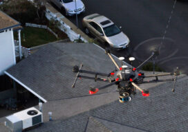
Mobile LiDAR scanner Hovermap was used to conduct an internal and external scan of the facility in just over an hour to capture accurate as-builts and CAD drawings.

Early 3D Scanning Competition: 1998 – 2000, Part 13
When you join a start-up, as I did in 1998 with 3D laser scanning pioneer Cyra Technologies, you worry about two things. One is if your start-up’s “new thing” will catch on in the market and your company will survive. The second is if a competitor will “out-invent” you with something better (and your company...
The Early Days of 3D Scanning, Part 6
1998: Launching 3D Laser Scanning into the Market I had the good fortune to be deeply involved with a pioneering vendor of 3D laser scanners and point cloud software. As I consider where that technology is today – a multi-billion dollar per year industry, the valuable benefits it has delivered to so many organizations and...
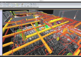
The Scan-to-BIM Process: Capture and Extraction
AECOM professionals adopt an integrated approach to best leverage the most current digital technology tools. With many aspects of the nation’s infrastructure reaching the end of its as-designed life, and with the purchasing power of construction dollars continuing to be stretched, developing systematic processes for determining the most cost-effective infrastructure investment strategy is critical. “Scan-to-BIM”...
Everything you ever wanted to know about Mobile Mapping
Explaining the tools and technology behind mobile mapping devices for experienced laser scanning professionals looking to make the jump to this new technology. In its short life, the market for 3D as-built documentation technology has seen considerable innovation. Among the myriad new tools to hit this market, nothing has changed the way we capture buildings...

Finding Flat Spots: Better Weighing (WIM) for Better Trucking
Laser scanning helps in building and troubleshooting weigh-in-motion stations for commercial trucks. With advances in automated traffic systems and improvements to traffic flows now common along many interstate highways, virtual weigh stations (also known as weigh-in-motion stations, or WIM) for commercial truck traffic are a logical development. This new type of station is an automated...