Tag Archives: scanning

xyHt Magazine April 2017 Issue
Click here to view the April 2017 issue of xyHt magazine

xyHt Magazine Heights 2017 Supplement
Click here to view the Heights 2017 Supplement to xyHt Magazine

xyHt News Links: 11/11/16
Trimble Software GNSS Receiver Provides High-Accuracy, On-Demand Positioning-as- a-Service Lead’Air Creates an Unparalleled Multi-use “HELIDAS” Oblique Camera System for Helicopter and Fixed-wing Aircraft Caterpillar and Trimble to Expand Mining Technology Collaboration Microdrones™ partners with Delair-Tech to offer complete aerial mapping toolkit Trimble Business Center Software Adds Scanning Module, Support for Complete Third-Party Data Integration and...

xyHt Magazine November 2016 Issue
Click here to view the November 2016 issue of xyHt magazine.
Prepping for El Niño
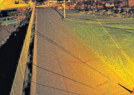
Above: A portion of a roadway that’s subject to flooding was scanned to perform drainage analysis as well as to map the existing conditions. As the severity of weather increases, so do the benefits of high-definition laser scanning for asset management and damage analysis. Editor’s note: Improvements in, and availability of, tools and resources for precise...

xyHt March 2016 issue
Click here to view the March 2016 issue of xyHt magazine.