Tag Archives: SenseFly
A Decade of Uncrewed Photogrammetry
Some might have had a peek at photogrammetry drones before 2013, but for me 2023 marks a decade since I first laid eyes on an uncrewed aircraft that “claimed” to do what I had been doing for years in bigger, more stable airplanes in the joyful company of pilots, copilots, camera operators, and navigators. In...

xyHt Weekly News Recap: 2/12/2021
senseFly Expands Line of Fixed-Wing Drones Trimble Introduces Next Generation of 3D Paving Control Bluesky Creates First 3D Map of Northern Ireland Coastline NSPS 2021 Student Competition WiBotic Launches Software Package for Robot Fleets Drones Made in America Photogrammetry Company Matterport to Go Public in $3 Billion Deal

Mapping an Historic Internment Camp
Above: By using drone technology to digitally preserve and reconstruct sites like the Amache Internment Camp, researchers, survivors, and the general public gain a better understanding of an important part of history. UAVs help scholars digitally preserve and reconstruct (in AR) the Amache Internment Camp in Colorado. As national landmarks age, documenting their structures to...
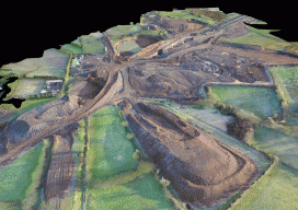
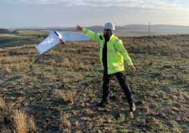
Over Roads and Quarries
A surveyor with a construction company in Northern Ireland uses UAVs to develop highway construction and for adjoining quarry quantities. Improving infrastructure has become crucial to local and global economies due to increased strain on roads and public transport from a rising population. When GRAHAM Construction and its partner, Farrans, were jointly awarded the contract...
Weekly xyHt News Links: 4/6/2018
Ouster Launches Two New LIDAR Sensors, Adopts NVIDIA DRIVE™ AI Platform Topcon introduces new laser series designed for distance and accuracy in construction projects What Drone Operators Need to Know About the Expansion of LAANC East View Geospatial Launches On-Demand Milspec Geospatial Data Topcon and Bentley to hold collaborative Constructioneering Academy in Brisbane senseFly and...
Weekly xyHt News Links: 3/30/2018
EdgeTech Introduces the 6205s Next Generation Swath Bathymetry & Side Scan Sonar System senseFly takes drone flight planning & management to next level with release of eMotion 3.5 CANSEL TO DISTRIBUTE MICRODRONES FULLY INTEGRATED DRONE SYSTEMS THROUGHOUT CANADA NASA completes third phase of UAS airspace testing Intergeo 2018 to focus on geoinformation, digitalization SBG Systems...