All posts by Jeff Salmon
Australian Aerial Innovation
Airborne Research Australia brings unique capabilities—including powered gliders reported to be more economical than UAVs—to a wide range of research projects. Airborne Research Australia (ARA) is Australia’s National Research Aircraft Facility and is hosted within the School of the Environment at Flinders University in Adelaide, South Australia. ARA’s capabilities are unique in terms of their...
Surrogate UAS
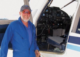
Above: Hart Drobish, president of Courtney Aviation, was a contractor to the forest service flying the air tactical control platforms on the Happy Camp Complex wildfire. Additionally, Drobish served as a ground liaison contact on the project, managing the flow of infrared and visual imagery from the aircraft to the end users. Combining UAV technology...
Legal UAS
Until the final FAA rules are in place for UAS incorporation in national airspace, the Section 333 exemption petition process is the only way to legally fly UAS for commercial applications in the United States. In late 2014, Government Accounting Office (GAO) stated, “The consensus of opinion is the integration of unmanned systems will likely...
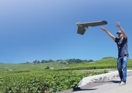
The Next Generation of UAVs
The future of unmanned aerial vehicles for the geospatial profession looks to include bigger platforms for better sensors. A Drone by Any Other Name The question came up recently: “What’s the difference between a drone and a UAV?” The short answer is: none, the terms are synonymous. Which opens up a big can of alphabet...
The New Spacescape
Small satellites are changing who dominates the field of satellite remote sensing. Move over military and government policy and regulation. Make way for private companies and even the public. There are big changes afoot in the satellite remote-sensing field: improved technology as well as regulatory shifts enabling the application of this technology (see “New Markets for Satellite...
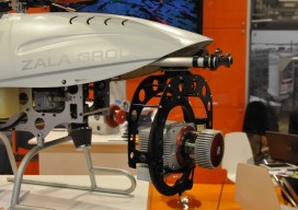
State of: UAS
Multiple names and acronyms are used for this technology: UAS, UAV, and the sadly ubiquitous “drone.” The mapping industry avoids the military connotation of “drone” and prefers UAS (unmanned aerial system) to UAV (unmanned aerial vehicle). UAS encompasses the entire system: the unmanned aircraft and sensor package, the ground control system, the control link, a...