All posts by Jeff Salmon
UAS Legislative Round-Up
What will 2016 mean for online commercial sUAS registration in the NAS? Online Registration Last year, registration for hobby/recreational sUAS went online. It was so simple I think it has confused people as to what the commercial registration process will look like. Because I have a recreational sUAS and am required to register it, I...
The Future of Treasure Hunting: Part One
We continue this series on treasure hunting with geospatial tools by taking a peek at what the future may hold for seekers of undersea hidden treasure. The tale of Mel Fisher and his hunt for the “Nuestra Senora de Atocha” illustrates the difficulties of undersea treasure hunting. The Atocha was the most famous ship of...

Underwater Drones Search for Czar’s Lost Treasure
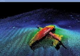
Continuing with our series (part one and part two) on the role that geospatial technology plays in treasure hunting, we come to the mysterious tale of the RMS Republic. Launched in 1903, the Republic was a part of the White Star Line, and, foreshadowing its sister-ship the Titanic, it sank six years later, 50 miles...
Treasure Hunting with Geospatial Tech: Part One
Geospatial tech is increasingly being called upon in the search for treasure. Let’s look at some examples, and maybe you, too, could discover hidden riches! Pangaea #155 As the wind keens and the snow piles up outside my door I retreat into my cozy home for some arm-chair treasure hunting. I start with the Travel Channel’s...
An Inside Look
The New FAA UAS Registration Recommendations The UAS Registration Task Force (RTF) Aviation Rulemaking Committee has recently published its recommendations. For an insider’s look, we talked to Altavian’s John Perry, a member of the committee. Unmanned & Unlimited: Could you give us your take on the process? As a representative of MAPPS and as a...
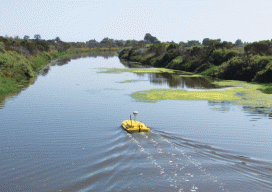
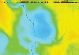
Aqua Bots
Above: The Z-Boat 1800 on a riverine hydrographic survey using sidescan sonar. Unmanned & Unlimited Unmanned aerial systems (UAS) get the lion’s share of media coverage, which is just not fair. Hardworking unmanned marine platforms, both surface and subsurface, have a lot to offer in the hydrographic surveying and inspection space. As a big bonus...