
Blog
UAS at The Intersection of Preparation and Opportunity
“Luck is what happens when preparation meets opportunity” —this advice is attributed to Roman philosopher Seneca. His counsel is particularly relevant to the current stage of UAS here in the U.S. Unmanned technologies have created big opportunities, and the FAA’s Rule 107 has unleashed them (to a high degree, arguably). Investors are paying attention. Just...

xyHt Magazine October 2016 Issue
Click here to view the October 2016 issue of xyHt magazine.

xyHt News Links: 9/30/16
Trimble Launches New Portfolio of Wireless IoT Sensors for Water Monitoring DAT/EM Releases Version 7.3 Orbit GT to launch Mobile Mapping v17 at Intergeo, Hamburg Geodetics introduces mobile mapping system with lidar, GPS senseFly and Maptek sign agreement around data collection and analysis solution DroneDeploy Speeds Up Drone Mapping for Remote Users With Limited Internet...

The UAS Platform, and How to Pick One
Secrets to Successful Selection Think UAS platform selection is cut and dried? Well, did you know that fixed-wing UAS, not multirotor, are the best fit for a specific (and growing) inspections market? Or that by choosing an amped-up multirotor UAS, your fee schedule could also get amped-up? Now that FAA Rule 107 is the law...
Surveyors of Tomorrow: GIS and Families
Over the past few years, I’ve been gathering quotes and anecdotes—from the kids of survey practitioners—about what they think other kids might find attractive about their parent’s chosen profession and why they might (or might not) choose the same path. Here’s a sampling that represents what I hear. The three children of Brad O, the...
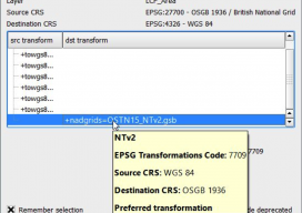
Using OSTN15 with QGIS
As you may be aware, the United Kingdom has a new transformation model that is OSTN15. But why? What does it mean to the geospatial community? Without being too nerdy, tectonic plate movement means that the “model” surface (the geoid) is slowly moving away from being the best fit for the coordinate system. It has...
Advertisement