Category Archives: Aerial/UAS
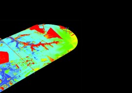
Single-Photon Lidar
SPL collects massive data from the air, uses less power, and can see through semi-porous objects with green lasers. Technological advances in our industry have truly been a sight to behold. It seems like when you blink, already there’s a faster, smaller version of the instrument you just bought. Look at aerial lidar, for instance–who...
UAS Crystal Ball 2017
Four things to watch for in the UAS space next year. Regulation: I just made up an acronym—“GBVLOS”—Getting beyond visual line of sight. With the rollout of the FAA’s Rule 107 allowing sUAS into the NAS for commercial work, the profession breathed a sigh of relief. Issues still remain, though: namely exemptions for BVLOS. So...
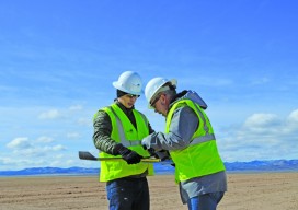
UAS: Measuring for Solar
Above: The Mortenson team prepares their senseFly drone for flight. With a UAS, a construction firm finds value—in addition to what can be measured—in real-time assessment and data availability. Surveying plays a crucial role in construction, from initial planning to final as-built verification, often in multiple phases. However, terrestrial survey methods come with challenges for...
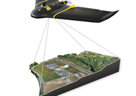
UAS Surveying without GCPs
The subject of applying direct georeferencing to UAS platforms was a recurrent theme at the 2016 Commercial UAV Expo last week. Direct georeferencing offers the possibility of mapping without the use of ground control points, providing UAS operators a significant advantage in terms of speed. As an example of this technology, we reached out to...
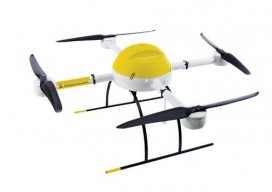
Drone design: What Goes into Designing a Drone?
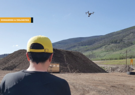
A UAS firm tackles a topographic mission at 10,000 feet above sea level with their own system. (Above: IST Aerial’s Bo LeRoy uses the firm’s DJI Inspire One to collect data for volumetric calculations for compost piles located on a landfill in Colorado.) IST Aerial is a division of Integrated Science and Technology (IST), founded 25...
Don’t Drone On: Drone Talk & Geospatial Professionals
How to explain the value of UAS to geospatial professionals. I’m the business development director at microdrones, where one of my goals is to help customers–who sell services like aerial mapping, surveying, infrastructure inspection, and monitoring precision agriculture–communicate to their potential clients the value of using UAS. This can be tricky in such a high-tech...