Category Archives: Aerial/UAS
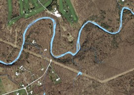
Mapping the Pennsylvania Lake Erie Watershed
Imagery was collected along 77 miles of shoreline to provide a better understanding of Pennsylvania’s natural resources. By Brian Stevens The Pennsylvania Lake Erie Watershed is a substantial part of the world’s largest surface freshwater system, the North American Great Lakes. The watershed is 512 square miles, consisting of 15 major sub-watersheds. It’s estimated that...

Geospatial on the Big (and Little) Screen
I get excited anytime I see the tools and technology of the geospatial profession in the media. Positive media exposure to the general public of all things geospatial can be a powerful tool to help build awareness for the profession. Additionally, it helps “build the brand” for the next generation, getting them interested in the...

Sensing Improvements? The Future of Lidar & UAVs
By Neil Sandler What does the future of lidar and UAVs look like in our world? We’re preparing this issue of xyHt just as we return from the important International LiDAR and Mapping Forum (ILMF) in Denver. Coincidentally, this issue will be widely distributed at the SPAR 3D conference and expo in Houston this April...
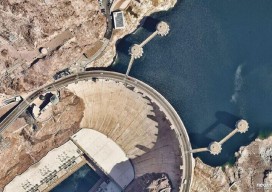
Converging Worlds Data, Imagery, and the Pipes Below
Above: Hydromax USA data (sewer and gas) is combined with Nearmap imagery and Esri software, improving analysis and resource deployment. A data-collection company transforms its services with clear, streaming imagery. By Nicholas Duggan, FRGS, Cgeog (GIS) When you get new aerial imagery, the first thing you do is look up your house. (It’s okay, we...

Will You Be Replaced by a Robot?
It’s difficult to open a magazine or look at a news site on the internet and not run across the “robots are going to take your job” theme. So, I’ve been doing a bit of reading on the subject, and I’ve come up with some very basic criteria for determining if your job may be...
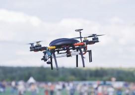
How to Prepare for Oops in UAV Management
Insurance Coverage for UAVs in 2017 It’s inevitable. If you own a UAV, chances are that you will experience a (hopefully only minor, but potentially major) type of accident-related claim involving that UAV due to human or technical error or to weather. Having been a broker in the insurance industry for more than 30 years,...