Category Archives: GNSS/Location Tech

22 Young Geospatial Professionals to Watch in 2022 – 1 of 22
Throughout January, xyHt.com will feature the young geospatial professionals who are making a name for themselves in everything from surveying to geographic information systems. xyHt featured all of them in the January issue. Here we will spotlight one each day for the next 22 days. Name: Alfredo Eduardo Arzamendia Maldonado Company: Ministry of Public Works...

Digitizing for the Future
Street-level imagery and GIS technologies are turning Philadelphia into one smart city Major metropolises are racing to get ahead of technology that could bring driverless cars and delivery drones to their streets and skies. In Philadelphia, investments in new software and services are already paying dividends in other ways for many of its 1.6 million...
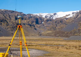
Affordable GNSS: Post-Processing Kinematic in the Cloud
In 1990 I had the privilege to work with a group of pioneers in Canada in the early development of land surveying techniques using a revolutionary new technology known as global positioning system or GPS. Back then, there was only a handful of satellites and the availability of a workable constellation that would allow for...

PPK or RTK: Which is Best?
Know your PPK from your RTK: How GPS correction systems are changing our understanding of landscapes Accuracy and precision are essential for any mapping or surveying task. When deploying a drone to do either, pinpoint location information can be enabled with GPS correction technology. There are two emerging and developing methods for doing this, namely...
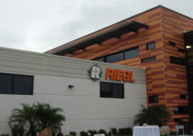
Riegl Officially Opens New Headquarters
On November 18th and under a persistent Florida drizzle, Dr. Johannes Riegl cut the ribbon that officially opened their new North American headquarters for business. Attended by over 150 people, Dr. Riegl and his son Johannes Riegl Jr., presided over a well-orchestrated and masterfully executed opening gala at the new Winter Garden, FL location. The...

Protecting Urban History
Researchers demonstrate how lidar, combined with imagery and hyperspectral data, helps prevent costly damage to historic buildings in urban construction zones. With every new underground urban rail or roadway tunnel, deep foundation shaft for a new building, or even simple streetscape upgrade, historically significant architecture in older city centers can become vulnerable. Earth displacement from...