A GPS on Bench Marks odyssey
Philip Melcher of Provost & Pritchard Consulting Group in Visalia, California, has submitted GPS on Bench Marks observations on an incredible 650 Bench Marks all up and down California in the last three years. We will ask Philip a few questions to find out how he has accomplished this, and to get tips for those interested in joining the program.
The National Geodetic Survey (NGS) GPS on Bench Marks (GPSonBMs) program involves collecting a minimum of four hours of static GPS data on existing Bench Marks and control points published in the NGS Integrated Database (NGS_IDB) and submitting the data via NGS’s easy-to-use OPUS Share program. Info on the GPSonBMs program can be found on the NGS webpage at https://geodesy.noaa.gov.
650 Bench Marks observed is quite an accomplishment Philip. How did you get started and how did your employer support you in this quest?
My co-worker, Tim Odom, and I had previously submitted a couple of marks that we set as well as ones we noticed had drastically settled when the ability to share OPUS solutions was originally put into place. I didn’t really get started sharing with such ambition until the launch of the GPSonBMs campaign for the GEOID18 hybrid geoid. One of our senior PLS/RCEs, David McGlasson, had asked if any of the surveyors would be willing to help with several priority marks that NGS was requesting observations on. Without hesitation, I answered the call, occupied, and submitted the requested marks.
I had several conversations with NGS staff because of the data I submitted. The multiple observations I made were in tolerance within each other but were far from the previously published elevations. I believe these discrepancies are what sparked my interest to keep sharing.
In the years of being a land surveyor, I’ve come quite accustomed to the inadequacies of NGS monuments in the California Central Valley. With GPSonBMs, I had a simple way of sharing what I had been observing and the ability to make a change; and so, it began.
Our founders, Jim Provost and Paul Pritchard, built a successful company on several key principles. One of which is to “Let People do what they love doing.” To this end, the company gives me sort of a free rein, and lets me utilize our equipment to tackle my ambitions, which has been incredible.
What motivates you to keep going week after week?
Adventure, history, science, and serving others.
Adventure: Without making my job seem boorish, because it’s far from it. I’ve been working for the most part in the same areas for the last 15 years. And I’ve possibly watched “Goonies” and other pirate movies too much. When I’m searching for monuments to set up on, it’s a huge treasure hunt. Too many of these marks haven’t been seen in 50 to 100 years or more, let alone remeasured.
With my searches, I am constantly finding myself off the beaten path, in new nooks and crannies I hadn’t previously explored, or just simply on a different route to my site. The datasheet is the ‘X’ on the map, which paints a picture of how to find the marks. Landscapes change, and many times, the subtle clues from the description let you find the original location.
History: I studied anthropology in college. It was definitely a mix of everything I loved: culture, archaeology, biology, paleontology, just everything as it relates to humans. My main focus was biological anthropology, but I was fascinated by ancient cultures. In archeology classes, the sites I was characterizing were 1,000 to 5,000 years old. Super old, and super disconnecting. What I can relate to is modern history and the profession I fell into-land surveying.
I am fascinated that these Bench Marks are a part of our living, breathing history and still serve a purpose. For me, observing these marks adds to the history and connects me with the mark. It is bittersweet that on most of these marks I am the first person to resurvey them, or just the first person to have at least added to the history of the mark.
Science: Citizen geodesist is such a perfect name for a person helping with GPS on Bench Marks; crowdsourcing people in the survey industry, licensed or not, but with a certain amount of skill and tools to provide data to measure and monitor the Earth.
Understanding the land we work in and measure needs this data. Although I’m not a scientist or a geodesist, being a part of the research by submitting my data allows me to be a part of the process. Working in the California Central Valley, subsidence is a major issue and is definitely not evenly distributed. A goal of mine is to dive deep into the problem and raise awareness, utilizing GPSonBMs as a platform to show what I see.
Serving others: I’m not sure what it is that drives me to jump in and help. I suppose it’s the fault of my parents. Always helping the church, family, friends, and neighbors. It was expected of my siblings and I to do the same. My parents put me into the Boy Scouts of America, where we did an incredible amount of community service. They saw me through to becoming an Eagle Scout while being heavily involved. Serving others has been a part of my life since an early age.
How does your GPS on Bench Marks activities benefit your employer?
A number of the Bench Marks I occupy are on private property or inaccessible without permission. I do insist on getting permission to come onto the property and talk with the owners or managers of the property about what I’m doing and why. I believe one benefit Provost & Pritchard receives is a favorable repute with the community.
There is an incidental benefit for anyone who uses geodetic control. Having control verified with updated descriptions and Survey Epoch Coordinates (SEC) in the NGS integrated database available to control surveys will ultimately save time and money for surveyors locating marks to base surveys upon.
Absolutely. Good surveys start with solid control.
Can you describe the process you go thru to recover, observe, document, and submit GPSonBMs data?
On every new job that gets placed on my desk, the first thing I do is search for marks in the area with the NGS Data Explorer. The most important thing for me is that any marks that land on, or that abut the property, I want to protect. Knowing the mark is there is half the battle of saving them. If one is onsite, I use that as my site benchmark. I also find an additional mark offsite just in case. Why would I use these instead of temporary control? Because these are loaded with history, which can tell a lot about someone’s property.
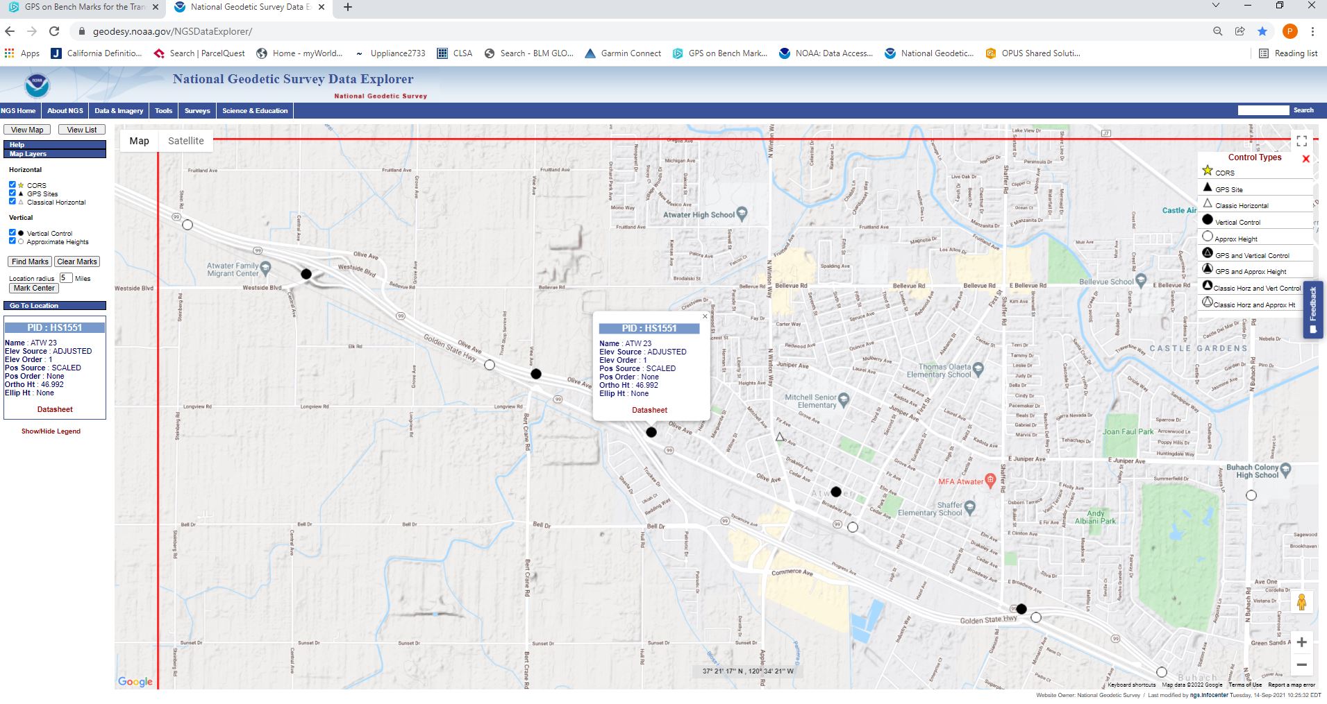
Figure1
My second task is to search on the “GPS on Bench Marks for the Transformation Tool” web map. Here NGS has specific priority and alternative marks they would like observed for the NAPGD2022 (North American Pacific Geopotential Datum of 2022) transformation. Most of these marks have been observed or located within the last 10 years, so in most cases your odds of locating the mark are high.
To be certain, armchair research can be done back on the NGS Data Explorer website. As an example, let’s take a look at ATW 23; PID HS1511 in Atwater, CA. I did a search for monuments around Atwater, CA (Figure 1).
Looking on the NGS GPSonBMs web map (Figure 2), I turned on Priority A (Yellow), Priority B (Blue) marks, with 10 and two-kilometer hexagons, and it appears NGS wants two four-hour observations on this mark because the dot is solid yellow without a red dot.
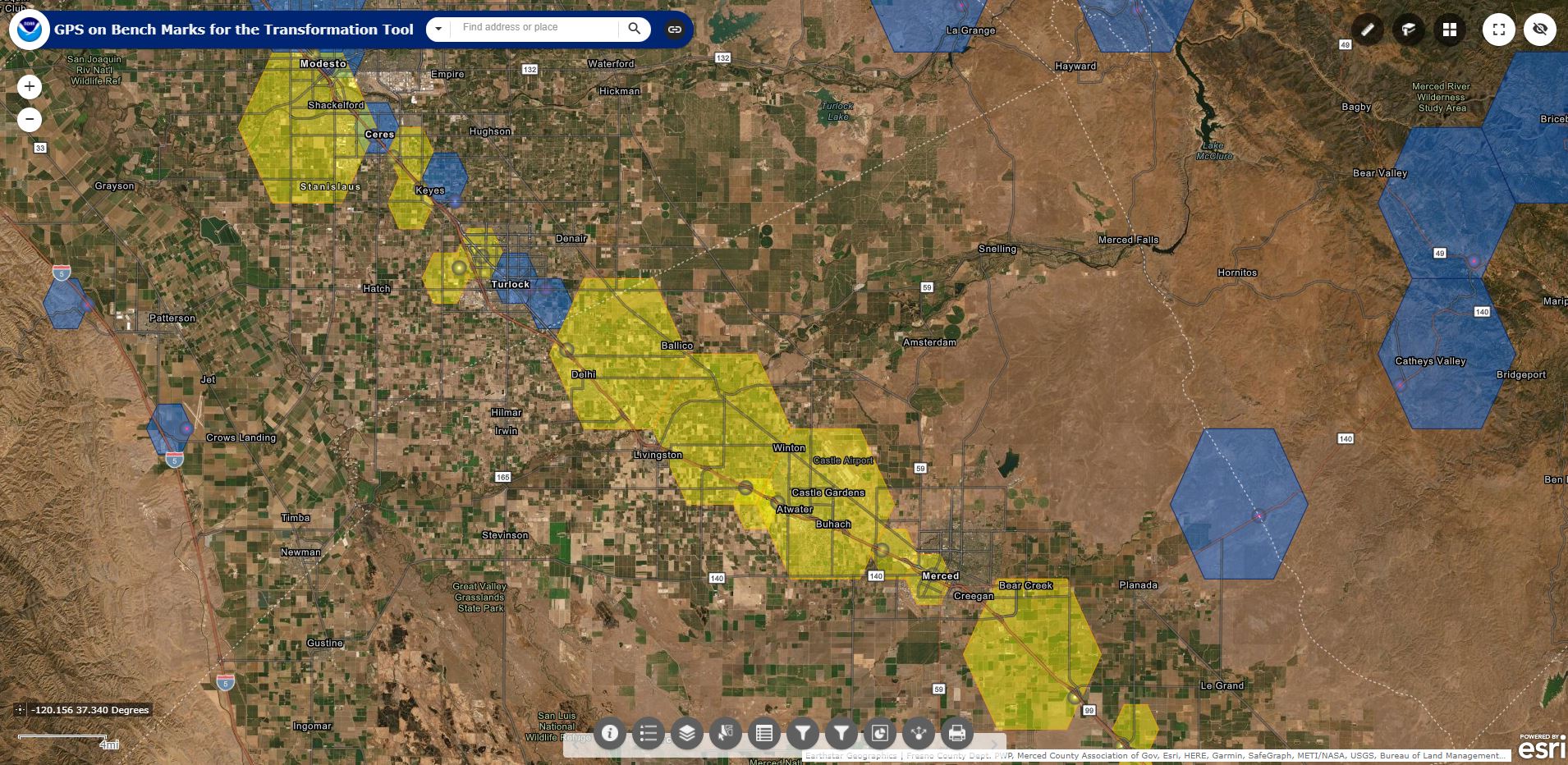
Figure2
In both maps, you can easily retrieve the datasheet, which should give you all the information you would need to locate it.
In the Datasheet for ATW 23 PID HS1551, the NAD83 LAT and LONG positions are indicated as “SCALED” source and not precise, so we’ll have to use the narrative description to locate the mark.
The narrative portion of the Datasheet tells us when it was found last, what type of mark to look for, and that AT 23 is set flush on the Southeast end of a traffic island.
In Data Explorer, you can go to street view to get a feel for the surroundings (Figure 3). The black dot in the grassy area is based on the approximate “SCALED” coordinates, however the mark can actually be seen painted on the center island, although the metal marker post appears to be gone.
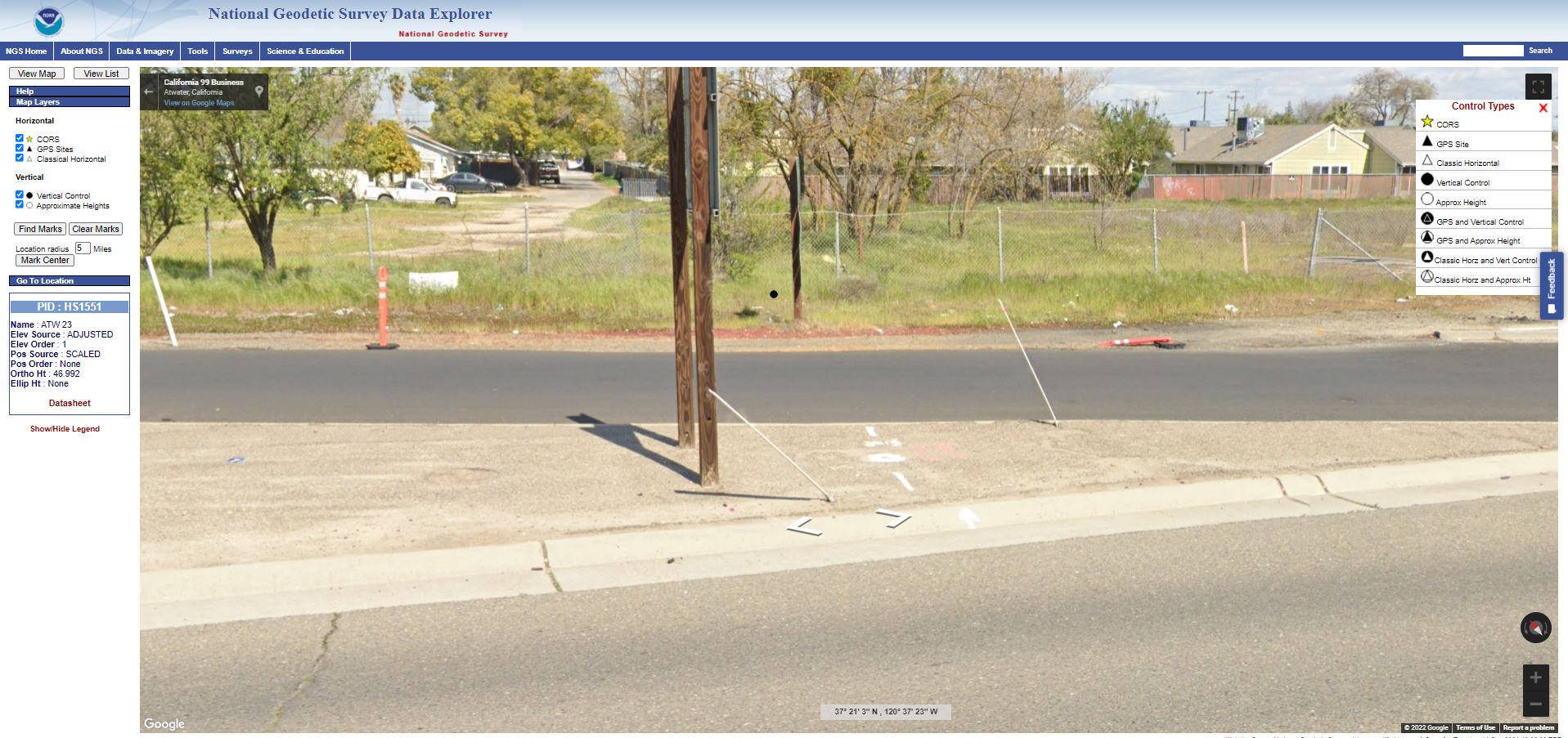
Figure3
I do this with all the marks I go after so I can plan my trips. I don’t like wasting time in the field, so I tend to always know which marks I’m after, prioritize which ones NGS is looking for. If I find one with coordinates that were determined by a handheld GPS, it will have a higher probability of being there because our geocacher friends have most likely seen it recently.
In observing the monuments, I might be the right guy with the right tools. From the first day I started surveying, our crews created our own control networks over large areas for irrigation clients. BenchMark-sitting was a common task of mine. New equipment emerged, swapping out a lot of older equipment for newer. We found it practical to keep the old ones we could use as a base station. With the rise of Real-Time Network RTK, our base stations started collecting dust. As subsidence started to become an issue to many of our clients, and areas we were monitoring became more vast, we started to do some static work again, typically with a couple of base stations (one with a long-range radio) to do RTK work. Leica Smartnet recently became a tool we could utilize in the South Valley, so we started checking further than our normal seven-mile radio range.
Several of our base stations are prehistoric, compared to our newer equipment, but are still relevant to the GPSonBMs program. I could only submit GPS anyway (the other GNSS aren’t used in the program yet), so I reutilized our old equipment to maximize my trips. Knowing your surroundings, you can judge whether a base station is worth leaving or needs to be guarded. Typically, heavily trafficked areas or areas in complete isolation have been my go-to, as people are curious and like to press buttons if there are buttons to press, aside from just stealing it.
For Mark Recovery or OPUS Share, you will need two to three pictures. One closeup of the monument, a horizon photo, which encompasses the GPS equipment set up on the mark and its surroundings, and if just a mark recovery, a photo of the monument at eye level.
At the site, I glance over the description and try to locate the ties to the mark. I note missing ties and or locate new ones for an updated description. I also note the quality of the mark-if it is solid in place or if it looks disturbed. The last thing I want to do is give good quality data on a bad mark. To help others before I leave the site, I announce its presence with flagging, setting a lathe next to it, and or painting around it. The next step is to submit your mark.
Sharing a mark is as simple as your normal upload to OPUS. Waiting 24 to 48 hours is typical for the ultra-rapid precise orbits to be available to OPUS. Once this occurs, head to the OPUS upload page, and just follow the pull downs to upload your RINEX file (usually your .m00 file unless you process your data through your software provider), antennae type, height of your Antenna Reference Point (ARP), e-mail address, and don’t forget the “options” button. Pull down to “Yes, Share.” This will prompt another page where you can enter the mark’s PID, add the photos, and add to the description.
You will get a shared datasheet for you to look over to make sure everything is correct. If everything looks good, check the box to accept and share the solution.
Do you submit mark recoveries for each Bench Mark recovered?
Unfortunately no. It took me a long time to figure out that the NGS_IDB and the OPUS Share program are separate and OPUS Share does not update the datasheets. So, there is an incredible amount of marks I haven’t submitted mark recoveries for. The new mark recovery tool, which you can access from your phone, makes it easy to submit a mark recovery on site or even locate marks in your area.
What advice do you have for someone who is interested in participating in the GPSonBMs program?
The easiest way to start is knowing what’s around you. Find a location where you are going to work and search the area for Bench Marks. If you can incorporate the monument into your survey, then utilize it.
For ones you can’t observe for at least four hours, then locate it, submit a mark recovery and announce its presence. NGS has been great to work with in helping with troublesome observations and there are incredible people in the survey community willing to help with truncating observations, if needed. Every observation counts and helps the locality.
How will NGS’s release of BETA OPUS Projects 5.0 help the GPS on Bench Marks program and your process?
OPUS Projects 5.0 will completely change the observation rate of Bench Marks. More will be found and more will be observed. The greatest asset of this will be the five-minute observation. Not everyone has the ability to babysit a monument for four hours or have the extra equipment to leave to the unknown. For me, more marks more often. In my subsidence region, trying to acquire one-centimeter quality isn’t needed when it sinks 30 centimeters a year. I believe participation in GPS on Bench Marks will exponentially improve.
Author’s note: NGS does not have any GPS observations for 93 percent of the marks in the NGS_IDB. Reliance on old and outdated published elevations, which in many cases have not been observed in 50 years or more, is highly suspect and can have profound consequences when used for Flood Certification or hydrological purposes.
Federal Register Notice 85 FR 44865 says: “Historically, NGS has combined data across multiple decades to estimate geodetic coordinates, yet such efforts have not fully accounted for the lack of information about vertical motion of geodetic control points throughout the years. Since height information is critical to the understanding of floods, failure to compute heights accurately can have negative impacts on property and lives.
NGS views periodic re-surveys of geodetic control points, rather than the estimation of coordinates from observations that are years (or even decades) old, as this is the most effective way to maintain accurate and up-to-date knowledge of geodetic coordinates, including heights. As such, this announcement provides users of the NSRS with advance notice that geodetic control points of interest to them should be re-surveyed for the most accurate representation of geodetic coordinates, including heights.”
Users of the National Spatial Reference System (NSRS) should now expect to participate in periodically resurveying the geodetic control marks they depend upon to control surveys.
NGS announced in December 2021 an extension to December 31, 2022, deadline for GPS on Bench Mark data submissions that will be used to develop the North American Pacific Geopotential Datum of 2022 (NAPGD2022).
As of this writing, Melcher and other California surveyors have completed 28 percent of the NGS 10-kilometer hexagons (or spacing) in the California portion of the GPSonBMs program. There are also two-kilometer hexagon goals to get a better definition in hilly areas or urban areas, which are currently 33 percent complete in California.
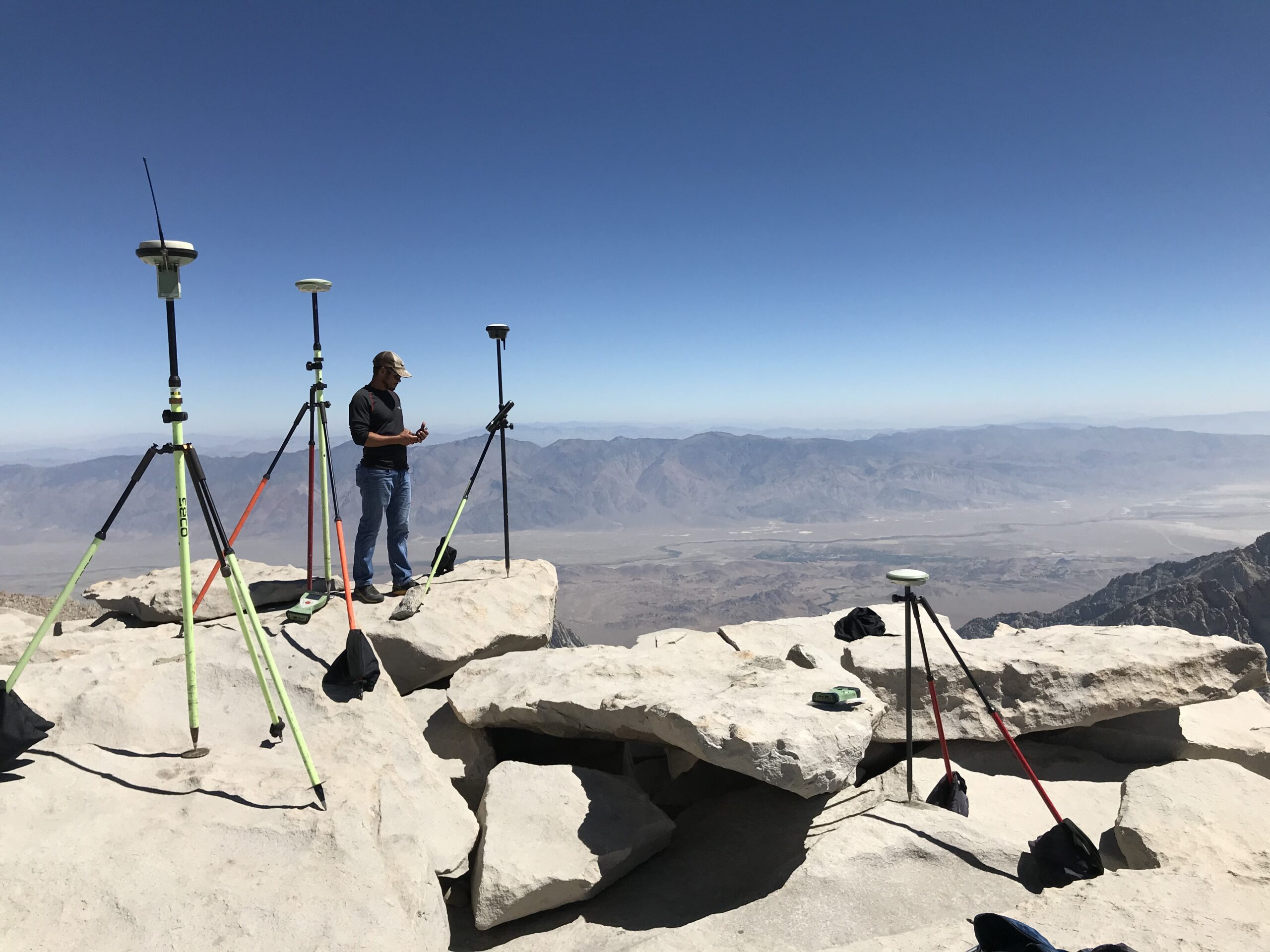
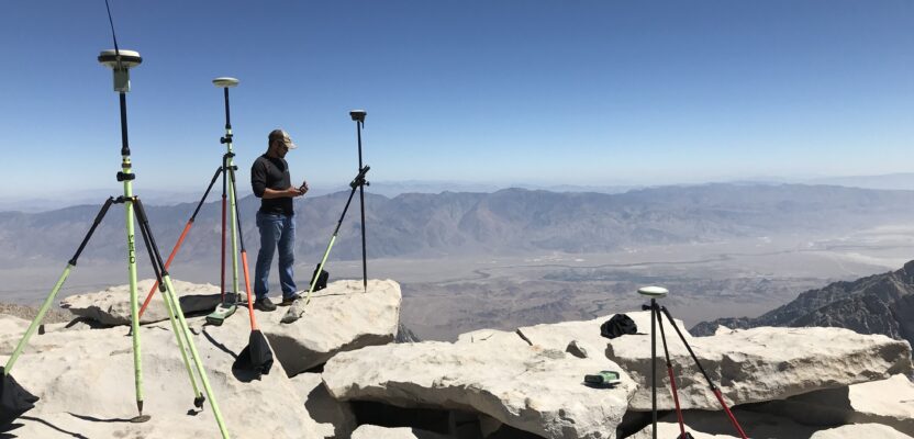
Philip Melcher on top of Mt. Whitney. Photo courtesy of Tim Odom PLS.