Category Archives: Lidar/Imaging

40 Under 40, 2017: Arnadi Dhestaratri Murtiyoso
RESEARCHER AT ICUBE LABORATORY, UNIVERSITY OF STRASBOURG FRANCE THE DIGITAL 3D IMAGING AND PHOTOGRAMMETRY REVOLUTION, enabled by UAS and its software boom, has expanded opportunities for talented young researchers in academia and commercial laboratories.The fruits of their research rapidly make it into your geomatics toolkits. Since his bachelor studies, Arnadi Dhestaratri Murtiyoso has been focusing...

Disparate Data for Marine Life
Remote sensing data helps to inform ocean planning for energy development around the main Hawaiian islands. Using remotely sensed imagery to map physical and biological patterns in the marine environment enhances our ability to understand how environmental conditions change over broad spatial scales (10s to 100s of kilometers) and temporal scales (years to decades). These...
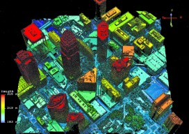
Single-Photon Lidar
SPL collects massive data from the air, uses less power, and can see through semi-porous objects with green lasers. Technological advances in our industry have truly been a sight to behold. It seems like when you blink, already there’s a faster, smaller version of the instrument you just bought. Look at aerial lidar, for instance–who...
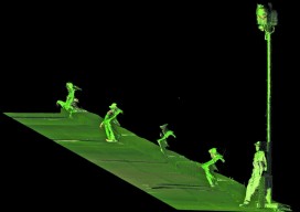
The Scanning Stalker: Who’s That In My Point Clouds?
There he is again. This is the third time today. I keep finding him in my scans–hiding behind some tree or peeking around a corner. I keep an eye out while I’m in the field, but I’ve never caught him in the act. I’ve gotten used to it over the years, but it still gives...
UAS Crystal Ball 2017
Four things to watch for in the UAS space next year. Regulation: I just made up an acronym—“GBVLOS”—Getting beyond visual line of sight. With the rollout of the FAA’s Rule 107 allowing sUAS into the NAS for commercial work, the profession breathed a sigh of relief. Issues still remain, though: namely exemptions for BVLOS. So...
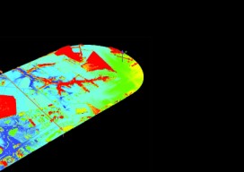
A Lidar That Oversamples: Geiger Lidar Imaging
Harris Corporation’s Geiger-mode lidar reaches new markets. Typical linear lidar systems repeatedly fire a single beam, each time measuring a single location on the ground. They collect data at a given resolution, which is also the processing resolution. By contrast, a Geiger-mode system is an array that illuminates a large area on the ground, capturing...