Category Archives: Lidar/Imaging

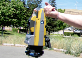
Trimble Unveils SX10 Scanning Total Station
Trimble unveiled a next-generation survey instrument—the Trimble® SX10 Scanning Total Station. It merges high-speed 3D scanning, enhanced Trimble VISION™ imaging technology and high-accuracy total station measurements into familiar field and office workflows for surveyors. The innovative solution provides surveyors and geospatial professionals with the capabilities and versatility to handle projects from traditional surveys to complex...
Full Kit: xyHt Looks at Cutting-Edge Surveying Gear
Topcon releases a complete surveying suite. The release is timely. For forward-thinking firms trying to meet increased demand, two key challenges are staffing up and gearing up. Many firms that have not added crews or upgraded kit for more than a decade are looking to do both in a hurry. xyHt attended several surveying and...
HxGN LIVE 2016 Unscripted
We’re shaking things up By trying a different way to convey the latest news and views from Hexagon Geosystems (aka Leica Geosystems–we’ll get used to the new name); we put some of the experts at HxGN LIVE 2016 in front of a camera for unscripted Q&A. Follow the embedded links to open the videos in...
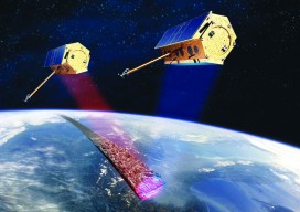
InSAR
How can you monitor broad-area land deformation with high precision? Why, from space, of course. Is it possible for satellites to accurately monitor the motion of landscapes with millimeter levels of precision? What about over wide areas while being frequently updated? If you scoffed in response to either of these questions, you might be surprised....

Demystifying Mobile Mapping
Above: A mobile mapping rig of the engineering consulting firm Tetra Tech; the crew mapped the entire 288 miles of roadways in the city of Redmond, Washington in six days of driving. A surveyor examines (and asks users a lot of questions about) the Pegasus:Two system. Editor’s note: How could measurements taken from a moving vehicle...

UAS & The Combo that Opens Access
The most logical integration of technologies for surveyors is combining 3D laser scanning with UAVs. It’s no secret that many geospatial professionals are enamored with unmanned aerial systems (UAS). For many years, the pros and cons of deploying small UAS for mapping and surveying, along with their ongoing regulatory discussions, have been well researched and...