Category Archives: Magazine

Cleaner Signals, Better Sites
How Antenna-Level Interference Mitigation Improves Machine Control Productivity. Construction job sites have always been challenging environments for positioning. Steel structures, heavy machinery, changing terrain, and partial sky visibility are part of the daily reality. What has changed dramatically over the past decade is the radio-frequency (RF) environment in which modern construction now operates. Today’s job...
Topcon 2.0 in Practice
How Connected Workflows Are Redefining Geospatial and Construction Execution Over the past decade, geomatics has shifted from a discipline defined primarily by measurement accuracy to one increasingly shaped by workflow execution. Sensors are more capable, data volumes larger, and project timelines tighter, while survey, GIS, and construction activities now routinely overlap. In this environment, the...

Trust at 165 MPH
What Endurance Racing Teaches Us About Precision, Performance, and Continuous Improvement The sun sets low over the flat Florida horizon. As daylight fades at Daytona International Speedway, the infield comes alive in a different way. Campers glow with headlamps and LED strips. Fans drift between trailers, timing screens, and television monitors. Some wake in the...
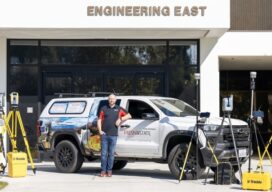
Building the Next Generation of Geomatics Professionals
How Fresno State, Trimble, and CSDS Are Closing the Workforce and Technology Gap On January 22–23, 2026, Fresno State hosted the 65th Annual Geomatics Engineering Conference at the Lynda and Stewart Resnick Student Union, bringing together students, educators, surveyors, engineers, and technology providers for two days of technical sessions, vendor exhibits, and professional networking. The conference, which has been...

Beyond the Science Project: Productizing the Future of Sensor Fusion
XYHT – Q&A with Peter Mardaleichvili and Lukas Meier, Fixposition When Fixposition showed its latest xFusion™ solutions at Equip Expo, Agritechnica, and INTERGEO, one theme came through clearly from OEMs and integrators: they are done with “science project” stacks. They want fusion that is robust, repeatable, and ready to ship. Fixposition says that is exactly what they are building: a productized...

Precision or Nothing: The Millimeter-Level Future of Geomatics
By any measure, INTERGEO 2025 marks a turning point for Topcon. But for CEO Ivan Di Federico, the momentum behind this shift started well before the show floor opened. It began last November, when he outlined what would become Topcon 2.0—a reset of the company’s identity that re-centers geomatics as a foundational discipline and sets a...