Category Archives: Spatial IT/GIS

Maptime – Grassroots Geo-learning
From beginners to experts: #maptime chapters worldwide provide opportunities for cartographers, mappers, geospatial practitioners—and anyone with an interest in maps—to learn from each other. The concept and impetus behind #maptime are very simple: people who create (or have an affinity for) maps and mapping getting together to share common interests, tips, tricks, and techniques. If...
Nick Bearman, PhD
GIS Educator, Geospatial Training Solutions & University College London – London, UK Nick Bearman is a gifted educator, with an extra bonus for the geospatial community in the UK (and increasingly worldwide) of a specialty in GIS. Bearman operates his own consultancy, creating custom training in GIS—both commercial and open source. He is also a...
Muhammad Luqman
PhD Student, University of Melbourne Melbourne, Australia A certified surveyor from Pakistan, Muhammad Luqman is currently a PhD researcher at the University of Melbourne in the field of Earth sciences. He completed his Master of Philosophy in geomatics in 2014 with a focus on the application of geospatial technologies, as well as a master’s in...

New Gold Standard for GPS
GPS users help map habitat along the Bear River for the Bear River Land Conservancy in Utah on June 7, 2017. Credit: Kirk Earl. As accurate GNSS data becomes democratized, there’s still a place to stand out in the industry. The long-established GPS industry has been facing a massive technological disruption for the past five...
What Is Esri?
Over the last few years we (at xyHt) have discussed Esri as an industry-leading GIS many times, but what is it? What is ArcMap, ArcGIS Pro, or any of the other things with “Arc” names? The truth is a little confusing, but at the same time a little clever. In this blog I hope to demystify...
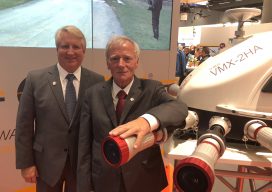
Seen at Intergeo
xyHt staff were out in force at the world’s largest geospatial conference in Frankfurt in October, and here’s what we saw of special interest. Riegl’s Big 4-0 Riegl celebrated its 40th anniversary at Intergeo. Pictured here are Jim Van Rens and Dr. Riegl, the company’s founder. New Vector Extraction in 3D Extraction of useful information...