Category Archives: Spatial IT/GIS

GIS in K-12
Above: Middle school students collect macroinvertebrates in Rocky Mountain National Park. The data will be mapped and analyzed using a GIS. Credit: Joseph Kerski. Where did you first learn about GIS? Was it in a course at a university or a community college? Were you an undergraduate or graduate student? Was it at a conference,...

Interview with Esri’s Ben Flanagan
Ever wonder who makes those maps you see in the newspaper? Ben has made maps for the Telegraph, the Guardian, and BBC News, and best of all (to me) he’s from the UK! Ben is like a ninja—not many people know about him but those that do are avid fans of his work. It was...
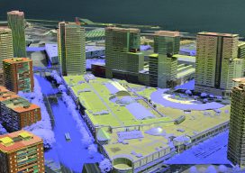
3D Cities from a Single System
Above: This screenshot is of CityMapper output. A look at the hybrid airborne system that combines lidar with oblique and nadir imagery. Over the last five years I’ve built and used a lot of 3D GIS and BIM models. Almost all of this has required the capture of stereo imagery and oblique imagery and a...
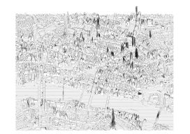
Creating Album Covers with GIS—or Drawing Elevation as Vector Lines
In July 2014, a developer and neocartographer from Scotland created the “Joy Divionesque 3D Map.” This began a four-year onslaught of maps that replicate the style of the iconic Joy Division album cover, “Unknown Pleasures.” How does it work? Essentially the elevation is taken from an underlying terrain or digital surface map as points, which...
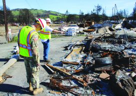
CA Wildfire Cleanup
The U.S. Army Corps of Engineers, under the direction of FEMA and in partnership with the California Governor’s Office of Emergency Services, removed more than one million tons of fire-related debris. Credit: Carol Vernon, Public Affairs, Pittsburgh District, USACE. The U.S. Army Corps helps rebuild lives with GIS technology. In October of 2017, numerous, fast-moving...

GIS Day
From the Coordinated Campus In a rapidly changing field such as geotechnologies, education is an ongoing concern and rightly so: if we are not lifelong learners, we won’t last long in this industry. But I contend that we as geospatial professionals also need to be aware of and provide leadership in larger geospatial education trends...