
Newcastle University was host to the 2019 conference.
Trends with UAVs, spatial data, and data use from GISRUK 2019.
GISRUK is the annual GIS research conference in the UK that showcases the latest in GIS (geographical information science) and geomatics research from the UK and across Europe. I attended the four-day conference at Newcastle University, and I was amazed to see the latest developments from across the geospatial community.
Is Spatial Still Special?
One of the key themes for me from the conference was the debate about whether spatial data is special, or is it just another data type, one among many?
For many years when GIS was a niche area requiring specialist skills, there was a clear argument that spatial was special. Now the bar of entry to using spatial data is much lower—through the use of tools such as Google Earth, Tableau, and even ArcGIS Pro—which means that many more people can get the benefit of using spatial data and analysis.
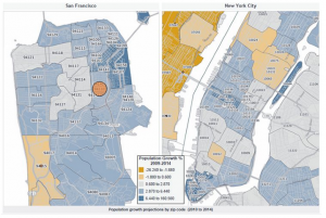
Spatial data is becoming more widely accessible, with many users in the third sector choosing Tableau for their spatial analysis over traditional desktop GIS.
Spatial data is now another tool in the toolbox of analysts, which allow us to be solution architects (solving problems) rather than geo-engineers (tinkering with projections and file formats). I don’t think we are yet at the point where using spatial data is as easy as using an Excel table, but we are so much closer than we were even just 5 or 10 years ago.
The traditional desktop GIS package (ArcGIS/QGIS) is no longer the only way of working with spatial data: advanced users have more data-science-orientated solutions such as Python or R, and non-technical users can get great maps from Tableau. In fact, at the conference James Bowles found many that many organizations in the third sector (charities and NGOs) use Tableau to do data analysis (including spatial analysis) rather than using tools like ArcGIS.
Early Career Researchers
One of the regular features of the GISRUK conference series is a key focus on early career researchers, those students who are currently studying for their MScs or PhDs. About 60% of them will go straight to work in industry after their studies, so this is a great opportunity for them to find out more about working in industry.
To demonstrate, both junior staff and senior consultants came in from ARUP (a multinational firm that provides engineering, design, planning, project management, and consulting services for all aspects of the built environment) to explain what ARUP does and why the students’ skills are vital in industry.
Growth Areas
One of the big areas of growth in GIS is the combination of remote sensing and machine learning; these skills are very sought-after by industry, and exciting developments are in the Earth-observation field.
ML (machine learning) and AI (artificial intelligence) are gaining a lot of coverage, both in terms of how and where we use them, but also from the point of view of “How do we use AI ethically?” and “What new questions do we have to think about when we are using AI & ML?”
One of the keynote speakers, Prof. Renee Sieber, talked about the importance of public participation in what she termed GeoAI (AI applied in a geospatial setting) and the fact that AI is not unbiased at all; it reflects our societal biases, and we need to be careful when using it.
The use of spatial data is fundamental to all of the work presented at GISRUK, and availability of data is often not as clear-cut as it should be. In the panel discussion on “How will the opening up of geospatial data help the GIS community?” one of the key elements discussed was data infrastructure. The provision of metadata is often quite important in terms of being able to select suitable data for specific projects, and if we are to further develop automated data process (including data selection), then comprehensive metadata is key to much of this, and currently fairly lacking.
Dr. Gobe Hobona, from the Open Geospatial Consortium, demonstrated how the OGC has been instrumental in developing a range of standards that are key to the interchange of spatial data between different software and organizations, including the provision of metadata.
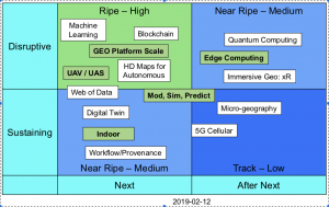
The Open Geospatial Consortium identified these upcoming trends.
Gobe also mentioned the developments of UAVs, both as tools for spatial data collection and as transformative decides in geospatial interoperability, allowing access to more and more varied data sources. UAVs are also very cool, such as the spectacular swarms of UAVs we saw at the recent Beijing Olympics!
UAVs were mentioned across many different themes in the conference, including for data capture, in combination with AI (to identify cracks in road surfaces), and to identify the impact on birdlife in wildlife reserves. They are clearly now entering a phase where they are part of a wider toolbox rather than a novelty in themselves, and so they are maturing into a new data source and product.
An interesting presentation by Kevin Minors was on crowd management, including techniques for modeling the crowd as a whole from a series of static data points, which has a wide application in highly variable crowds such as railway stations.
Overall this was a great conference providing a fascinating insight into the cutting edge of research in spatial data and GIS. Next year GISRUK is at UCL and Birkbeck, University of London, April 21 to 24–see you there!