Tag Archives: ESA

xyHt Weekly News Recap: 07/01/2022
Letitia A. Long to Receive 2022 Lundahl-Finnie Lifetime Achievement Award Nation’s First Drone-on-Demand Mobile App Now Downloadable on All Devices Cartegraph Launches Right-of-Way Permitting Solution for Local Governments Airbus awarded FORUM Earth monitoring satellite contract from ESA South Korea launches KASS satellite to augment GPS SUE Association Announces National Conference Esri to Donate Software for...

xyHt Weekly News Links: 12/1/17
Hemisphere GNSS debuts scalable smart antenna Orbit GT releases 3D Mapping Publisher v18 3D Laser Mapping launches campaign to release open-source LiDAR data SimActive Introduces New Technology for True Orthos Marine-i Event creates an exciting vision of the future Applanix and Think 3D Deliver UAV Lidar Mapping with Direct Georeferencing GIS Tools in EDU PR...

xyHt Weekly News Links: 7/28/17
INTERGEO – bridge to a digital future New Leica Captivate Pipeline application streamlines tracking and reporting Trimble introduces new Android app – Trimble Penmap – for field surveying and data collection ESA communication team hands off responsibility to GSA LizardTech optimizes Portfolio 2017 for geospatial data Icaros and TeAx Announce an Integrated Drone Mapping Solution...

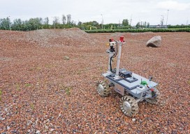
Robots for ExoMars: Drones and Space Exploration
Drones are being used to test a space rover in familiar ways. By Martin Azkarate UAV manufacturer senseFly talked to Martin Azkarate of the European Space Agency about his work developing rover prototypes for planetary exploration, including how he employs a senseFly drone to test these cutting-edge robots. Martin is a space automation and robotics...
