Tag Archives: faa
Embracing the Drone Revolution
Surveyor business models changing in the BVLOS era Over the past few months, the Federal Aviation Administration (FAA), working with the drone industry, academia, and general aviation membership organizations such as AOPA (www.aopa.org) and NBAA (www.nbaa.org), has been able to advance the cause of uncrewed flights beyond visual line of sight of the operator (BVLOS). ...

Final Approach
The demise of a great mapping platform With the advent and adoption of new technologies, we are quick to forget about the old ways we used to do things. In the case of pocket calculators or disposable cameras is not relevant to reminisce about the past, but when the time comes to dispose of a...

Drones in Construction
For decades the construction industry didn’t change much-and then UAV technologies came along Unmanned aerial vehicles (UAVs) or drones, as they are commonly called, are mostly electric-powered aircraft, which do not require a pilot onboard and are used to perform tasks that are either too dangerous for humans to do or too expensive with other...

xyHt Weekly News Recap: 02/11/2022
SBG Systems Introduces its First Tactical Grade IMU on the Market New Commercial BVLOS Milestone – Longest Distance Allowed by FAA at 12 Miles Phase One Launches iX Suite for Seamless Aerial Mapping Workflow Vexcel Introduces MapControl SDK to Help Developers Integrate Aerial Imagery New Surveying and Mapping Textbook Available for Download Vexcel Announces Image...
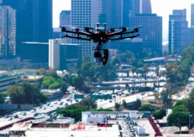
2022 and the Promise of Expanded UAV Operations
What needs to happen over the next 12 months for the promise of flights beyond visual line of sight (BVLOS) to become a reality? Well, actually, quite a lot. The Federal Aviation Administration (FAA) needs to relax the rules for unmanned aviation and the industry needs to prove that current technology, such as detect and...

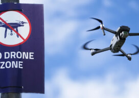
Taking Flight
As drones begin to fill our airspace, Switzerland is figuring out how the skies will remain friendly